Variable width buffer strips
What
Grass buffer strips or filter strips are areas of permanent vegetation situated between a paddock and the waterway they drain into. These buffers are intended to intercept and slow overland flow and reduce the discharge of contaminants to a waterway.
Variable width or contour buffer strips offer some significant benefits over fixed-width buffers as areas with different characteristics require different degrees of protection. The variables used to calculate width, such as slope, presence of wetlands, and width of floodplain, are selected because they are highly correlated with buffer effectiveness and are easily measured in the field. Overall variable width buffers are more scientifically defensible and more likely to provide adequate but not excessive protection. Variable width buffers can incorporate protection for other sensitive natural features, such as floodplains, steep slopes, and wetlands.
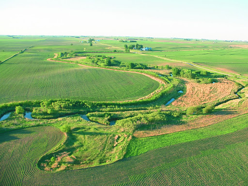
Image credit: Lynn Betts, United States Department of Agriculture.
Why
Stream buffers when left undisturbed help to protect water quality by trapping and removing contaminants, nutrients, and sediment from overland flow, stabilizing stream banks and reducing channel erosion, and storing flood waters. However, the ability of the buffer strip to provide these functions depends on several factors as indicated in the following table.
| Intrinsic | Physical | Ecological |
|---|---|---|
| Buffer width | Soil type | Vegetation structure |
| Buffer length | Slope | Growth rate of vegetation |
| Degree of fragmentation | Floodplain width | Density of vegetation |
| Buffers position in the catchment | Valley floor morphology | Presence of wetlands |
Calculating Variable Buffer Width
Variable Width Option 1
Base width is 30 meters plus 0.6 meters per 1% of slope of the stream valley.
It is extended to edge of floodplain.
It is extended by the width of wetlands that lie within or partly within the buffer (as determined by slope and floodplain width).
Existing impervious surfaces in the riparian zone do not count toward buffer width (i.e., the width is extended by the width of the impervious surface, just as for wetlands).
Slopes over 25% do not count toward the width.
The buffer applies to all perennial and intermittent streams.
Ephemeral streams are not protected by buffers, but their banks\ must be vegetated.
Variable Width Option 2
Base width is 15 meters plus 0.6 meters per 1% of slope of the stream valley.
Entire floodplain is not necessarily included in the buffer, although potential sources of severe contamination should be excluded from the floodplain.
Existing impervious surfaces in the riparian zone do not count toward buffer width (i.e., the width is extended by the width of the impervious surface, just as for wetlands).
Slopes over 25% do not count toward the width.
The buffer applies to all perennial and intermittent streams.
Ephemeral streams are not protected by buffers, but their banks must be vegetated.
References
Wenger, S. J., & Fowler, L. (2000). Protecting stream and river corridors: creating effective local riprian buffer ordinances.