Hydrology
Hydrology is the process that transports contaminants, either dissolved in water or as suspended particulate material carried by water. Therefore, it is a critical process for understanding ‘how’ and ‘why’ water quality varies across New Zealand and what actions are most appropriate to minimise contaminant losses.
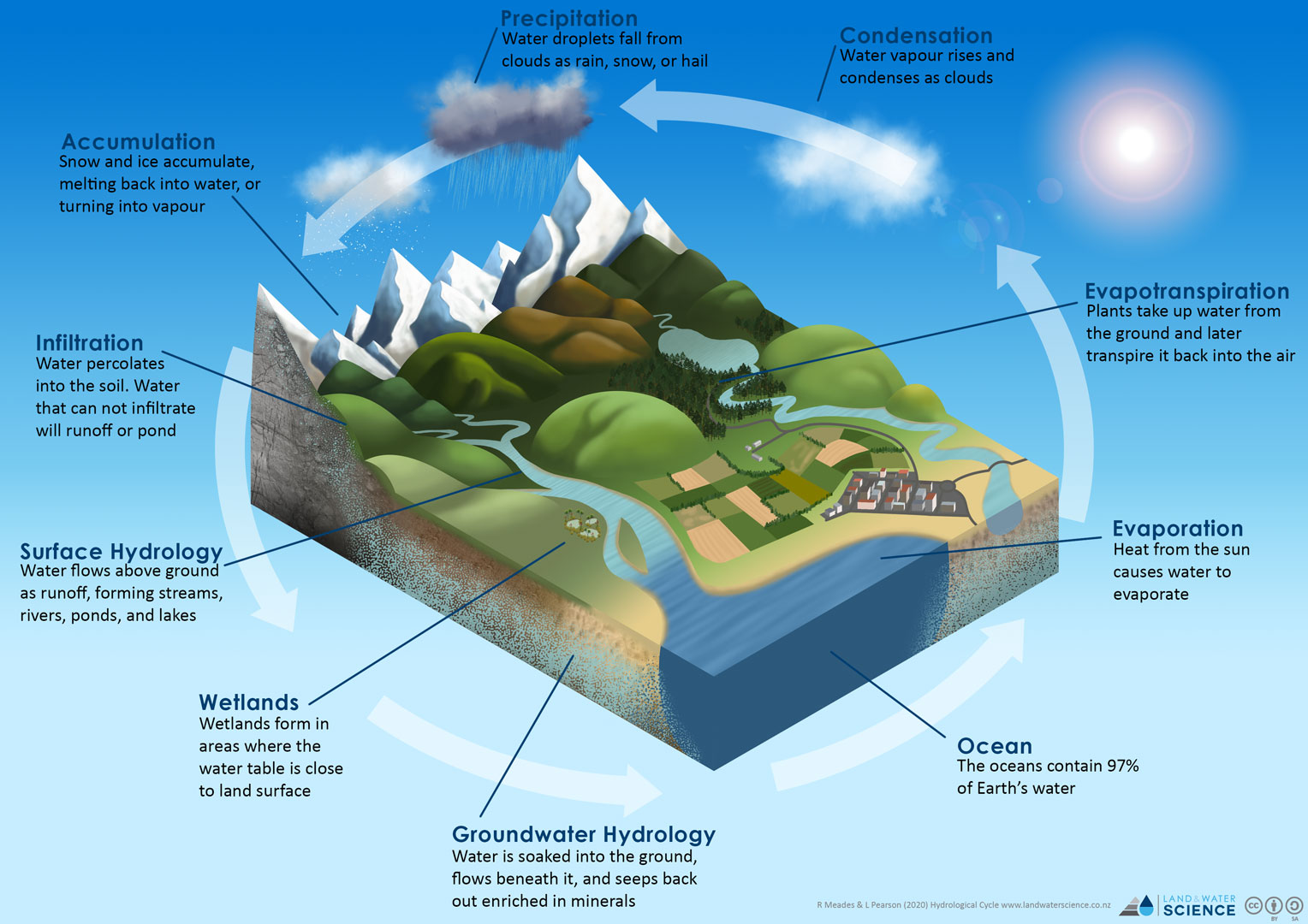
The hydrology of freshwater is separated into two main components, surface water and groundwater. Surface water includes all the water above ground, such as rivers, streams, lakes, ponds, and wetlands. While groundwater is the water present beneath the Earth\‘s surface in pore spaces and in the fractures of rock. They are connected by the water cycle which is nature’s way of “recycling” water through the continuous movement of water within the Earth and atmosphere.
This section explores key concepts relating to surface and groundwater that are critical to understanding the controls over water quality and the management of freshwater resources.
Watch the video below for an introduction to hydrology and its importance for water quality.
What is the water cycle?
Water is present on Earth in three states – solid, liquid, and gas and is cycled within the Earth and the atmosphere by the water cycle. The water cycle can be simplified to the circular cycle of evaporation, condensation, and precipitation where liquid water evaporates into water vapor, condenses to form clouds, and precipitates back to earth in the form of rain, hail, and snow. Liquid water flows across land (as overland flow or surface runoff), into the ground (infiltration and percolation), and through the ground (groundwater). Groundwater is used by plants (plant uptake) and evaporates from plants back into the atmosphere (evapotranspiration).
Surface Water
Surface water is all water on the surface of the planet and includes all the water in rivers, lakes, wetlands, and oceans. Here our focus is the terrestrial environment and the movement and cycling of freshwater.
What pathways does water take across or through the landscape?
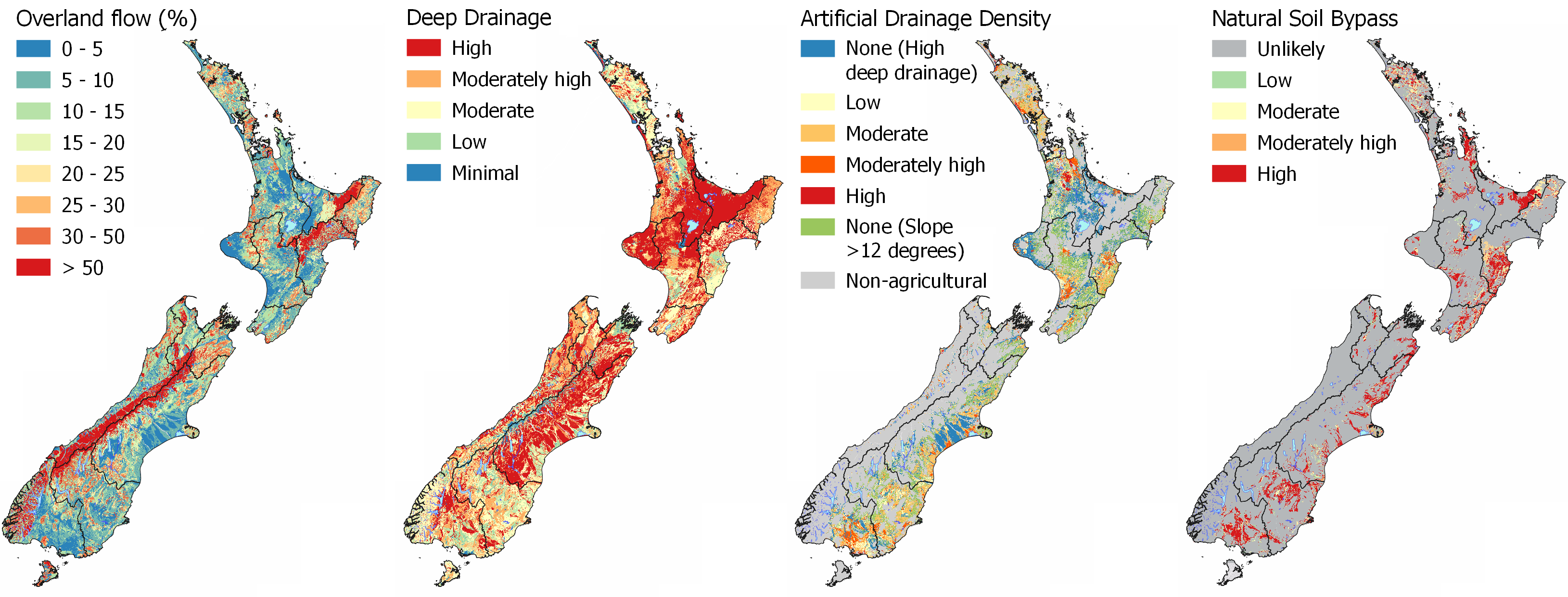
Water is the mechanism that transports all contaminants from the land. Therefore, the pathways that water takes to drain from the land are critical to understanding what contaminants are likely to be mobilised and how to minimise losses. These pathways can be predicted from the topography, soil, and geological properties. The figure below shows an example of how the hydrological pathway changes depending on the composition of the soil and topography. The climate and seasonality of precipitation also plays a critical role in the timing of when contaminants are lost during the year.

The main hydrological flow pathways are:
- Deep drainage through the soil zone into the underlying aquifer (groundwater).
- Lateral drainage occurs through the soil along the contact with shallow bedrock or slowly permeable layers in the soil zone.
- Artificial drainage is used to improve drainage where soils have either poor drainage or slow permeability in agricultural areas.
- Overland flow via surface runoff.
- Natural bypass flow when high clay soils are dry and cracked.
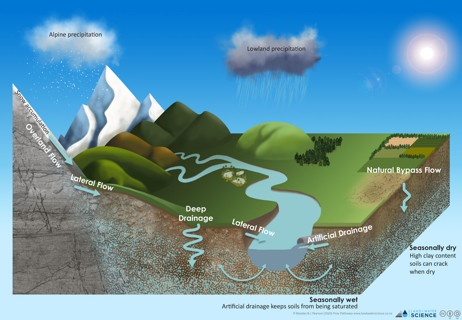
What is deep drainage?
Deep drainage (or groundwater recharge) is where water moves downward through the soil profile. Recharge is the primary method through which groundwater enters an aquifer. Contaminants that move through this pathway are leached. Leaching is the transport of dissolved species through the soil into an aquifer (groundwater). The loss of nitrogen, in the form of nitrate, is an example of a common environmental contaminant transported by leaching.
What is lateral flow?
Lateral flow occurs where there are layers within soil and geological substrate that have a low permeability (i.e., shallow bedrock, soil pans etc). Water saturates at the contact of the impeding layer and drains laterally to surface water. Minimal contribution to groundwater can occur from lateral flow. Lateral flow is common in areas where there is shallow bedrock, such as in the Bedrock Environment (hill country). We often see seeps occurring where lateral drainage flow paths converge with the land surface. Lateral flow also occurs close to waterways with a high water table.
What is artificial drainage?
Artificial drainage speeds up the lateral flow through the soil. It reduces the moisture in soil and thereby increases the amount of air which provides conditions for optimal growth of crops. Artificial drainage includes surface ditches, in addition to subsurface, mole and tile drains. Open ditch drainage is typically used to lower the water table. Open ditches in conjunction with subsurface drainage are used to improve drainage through poorly drained soil.
Contaminants transported in artificial drainage will vary depending on the redox condition (see SCIENCE – CHEMICAL PROCESSES). Oxidising areas are most likely to transport nitrate-nitrogen to waterways, while reducing areas are most likely to contribute ammoniacal and organic nitrogen, and dissolved reactive phosphorus. Artificial drainage can change the redox condition in soils with poor internal drainage by increasing the amount of oxygen in the soil resulting in the soil acting like an oxidising well drained setting.
What is overland flow?
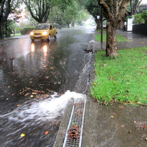
Overland flow (also known as surface or surficial runoff) is the flow of water that occurs when excess rainwater, meltwater, or water from other sources flows over the surface of the ground. This might occur because soil is saturated to full capacity (saturation excess overland flow), because rain falls more quickly than soil can absorb it (infiltration excess overland flow), or because the land surface is impervious (e.g., bare rock and roads).
Overland flow transports water, solutes, and particulates from the land surface to a surface water body quickly. As there is minimal interaction with the landscape for any contaminant retention or removal to occur, this pathway poses the highest risk to water quality from land use. It is also the primary pathway for soil erosion by water.
For overland flow to pose a risk to water quality it requires a contaminant source. This means overland flow occurring in natural state areas, contribute only background contributions to the contaminant load.
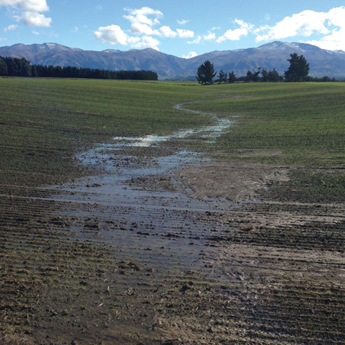
Example of overland flow occurring in a paddock.
Image credit: DairyNZ
Example of urban surface runoff (overland flow).
Image credit: Envivo Ltd.
What is natural soil bypass?
Natural soil bypass occurs in areas where there are clay rich soils that are prone to cracking when dry (under soil moisture deficit). Soils formed in calcium-rich parent materials and magnesium-rich mafic parent materials are most likely to have these shrink-swell clays. As the soil dries out, typically during summer to early autumn, cracks form leading to drainage water bypassing the soil matrix. Older soils with joints that form between poorly permeable areas are also important bypass pathways for water.
Cracks and joints in the soil become a preferential pathway for water to drain through. As the drainage is rapid, there is minimal contaminant removal from the soil zone. High concentrations of microbes, such as E. coli, in groundwater is typically from this transport mechanism. In areas where artificial drainage is also present, these cracks can connect to the subsurface drainage network. Contaminants can directly enter a surface water body in these situations.
Explore the MAPS - HYDROLOGY for interactive maps to compare the flow pathways of Overland Flow, Deep Drainage, Lateral Drainage, Artificial Drainage, and Natural Soil Bypass at your location.
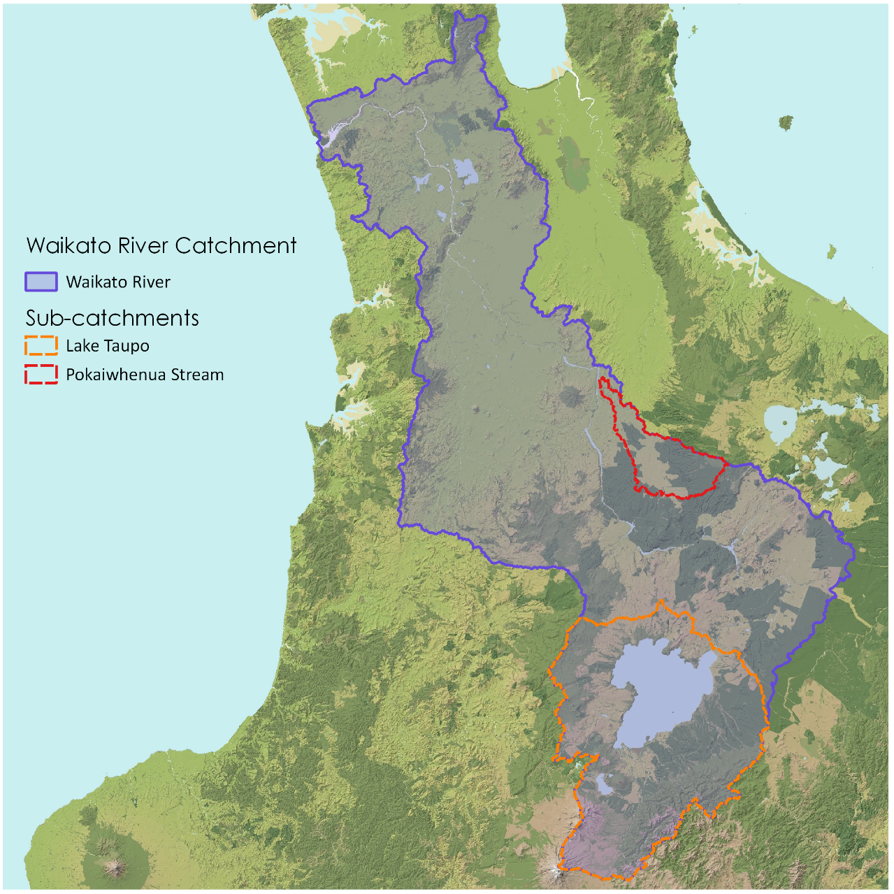
Surface Water Catchments
A catchment area is a term used to describe an area which collects each drop of water (rain) that falls into that area and which eventually ends up in the same river or stream going to the sea.
A catchment (also known as a drainage basin) is a basin shaped area of land bounded by natural features, such as hills or mountains, from which surface and subsurface water flows into streams, rivers, and wetlands. Water flows into, and collects in, the lowest areas in the landscape.
Why is it important to know your catchment?
No catchment is exactly like another. Each has a different size, shape, drainage pattern and features that are determined by natural processes, particularly geology and climate.
The geology of your catchment will influence many of its characteristics, from the stability of the streambanks and streambed to the natural chemistry of the water. Climatic processes and flowing water erode and shape the land. As rocks are broken down into smaller pieces they can be transported in the flow. Fine materials are transported as sediment throughout the catchment. Weathered rock and organic matter make up the soils that blanket the landscape. Soils have different textures, mineral content, structure and drainage properties. The nature of the soils in your catchment will have a key role in deciding how much water runs off the land and how likely the land is to erode.
The concept of a catchment is useful, because it is the scale on which many parts of the landscape work. The soil, plants, animals, and water all function together in a catchment – anything that affects one of these will also have an impact on the others. Therefore, if you want to improve water quality in a river, you need to know the contributing area to that river and the factors that are affecting water quality.
What is a drainage network?
The system of streams which transport water, sediment, and other material from a catchment is called a drainage network.
Tributaries are small feeder streams that empty into larger streams or rivers. The catchments of tributaries are referred to as sub-catchments. Large catchments are often made up of a number of smaller sub-catchments.

What is stream order?
The branching nature of a river and its tributaries are known as the stream order (or Strahler order). It is used to define the size of a stream based on the hierarchy of the tributaries flowing to a point of interest. If two tributaries of the same order combine, the next ‘order’ in the sequence is used to define the stream order (i.e. 1+1 = 2, 4+4 = 5). A lower order stream joining a higher order does not change the stream order (i.e. 1+3 = 3).
Whatever happens in each of the smaller streams affects the overall wellbeing of the main waterway. Therefore, to make improvements in water quality in a larger stream our focus should be on improving the low order streams.
In MAPS you can turn on the riverlines to view the stream order. Stream order is sized from 1 smallest to 8 largest.
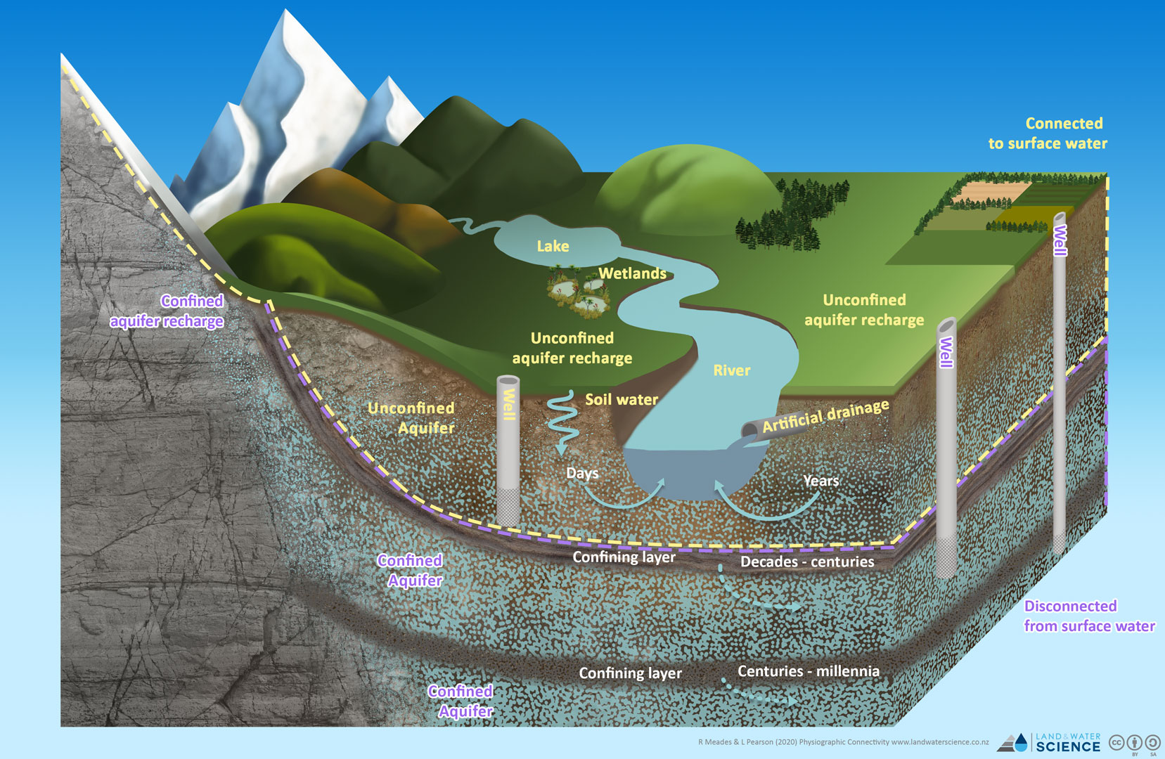
Groundwater
Groundwater is the water present beneath the Earth\‘s surface in pore spaces of unconsolidated material, such as gravel and sand, and in the fractures of rock. Rock or unconsolidated material saturated with water is called an aquifer when it can yield a usable quantity of water. We access this water through the drilling wells (or bores).
Water from aquifers drain to streams and sustain the baseflow of a stream or river. Lakes also receive water from groundwater as a subsurface flow. Groundwater discharged at the land surface is called either a spring (continuous rapid flow) or seep (intermittent slow flow). Wetlands are a common feature around seeps.
Groundwater accounts for roughly 30% of New Zealand’s water usage and is essential for environmental and social well-being and economic productivity. Wells drilled into aquifers provide water for drinking, agriculture, and industrial uses. Groundwater in an aquifer can dry up when wells are drained faster than nature can refill (recharge) them. Because aquifers fill with water that drains from the land surface, they can be contaminated by any contaminant found on the surface.
What is an aquifer?
An aquifer is an underground layer of water-bearing rock. Aquifers are permeable, meaning they have openings that liquids and gases can pass through.
In New Zealand, the most common type of aquifer is formed in unconsolidated sediments - sand and gravel where the individual grains are not cemented together to form solid rock. The groundwater in these aquifers flows through the interconnected pore spaces between grains of sand and gravel. In some areas, particularly in the North Island, the groundwater flows through interconnected cracks in fractured volcanic rocks, such as basalt. Some areas have limestone aquifers, where the groundwater flows through cracks and joints in the limestone. Overtime these cracks can grow very large as the groundwater dissolves the limestone and limestone caves are formed.
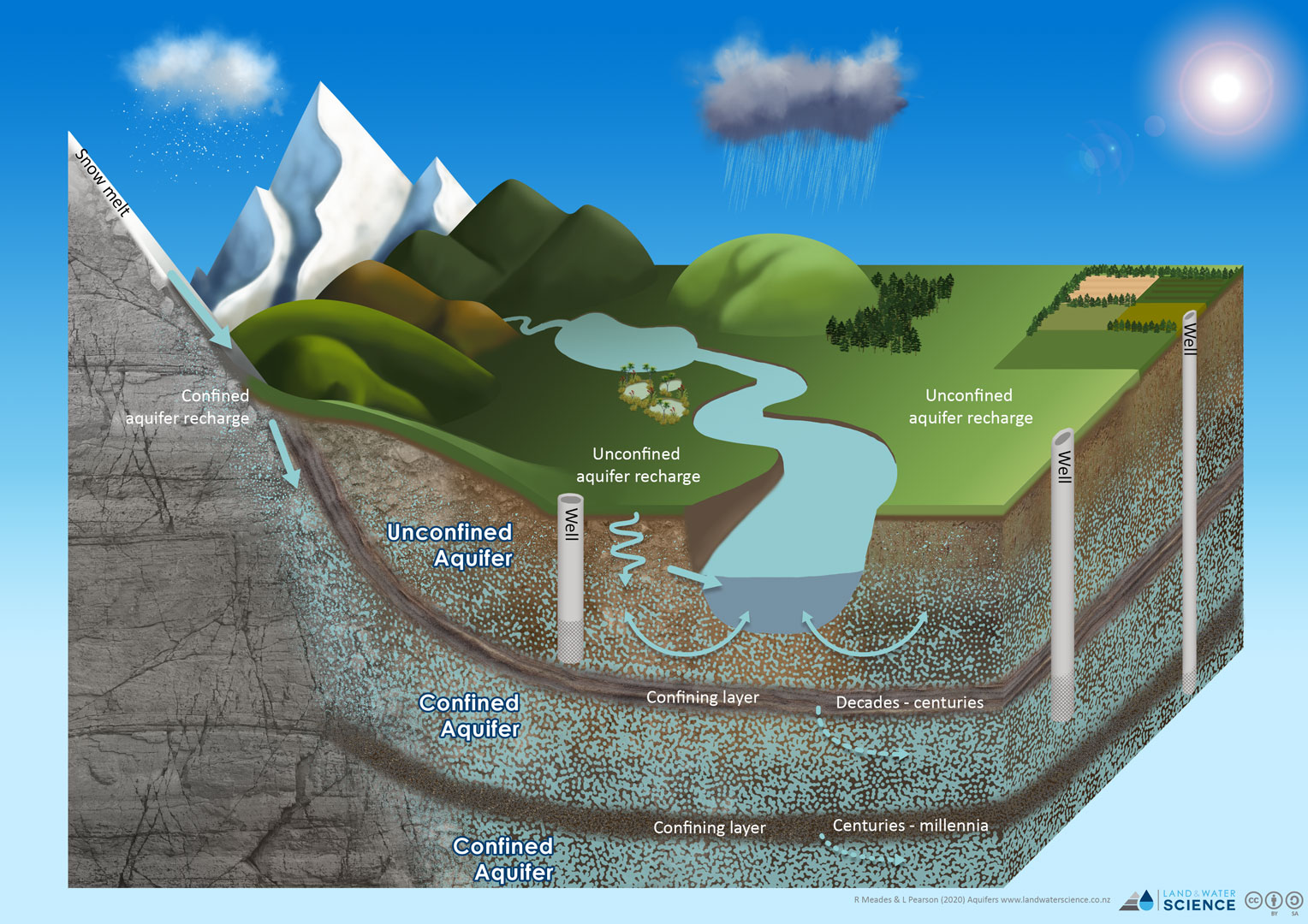
An aquifer fills with water (recharged) from rain or melted snow that drains into the ground. In some areas the water passes through the soil on top of the aquifer and in other areas it enters through joints and cracks in rocks (fractured rock aquifer). The water percolates downward until it meets less permeable rock.
Water in an aquifer is constantly flowing, just much more slowly than water flowing in rivers and streams. Groundwater flows through the aquifer from the recharge area (the area where water seeps into the aquifer) to the discharge area (an area where groundwater emerges back onto the ground surface as springs or seeps either at the land surface or as subsurface flows into rivers, streams, and lakes). Typical flow rates for groundwater in New Zealand are less than a metre per day. In some parts of New Zealand, however, flow rates of tens or even hundreds of metres per day have been measured.
What are the types of aquifers?
There are two types of aquifers. An unconfined aquifer is covered by soil and permeable rock and can receive water from the land surface directly above. The top of the water level in an unconfined aquifer is called the water table. The water table describes the boundary between water-saturated ground and unsaturated ground. Below the water table, rocks and soil are full of water. The water table of an unconfined aquifer rises or falls depending on the amount of water entering and leaving the aquifer. Relatively, this water is young and hydrologically connected to the surface water network. This means the activities we do on the land can have a big impact on the quality of this water source relatively quickly. This is especially important as groundwater is the source of water to streams and rivers when they are at their lowest flow (base flow) over the drier summer months.
The other type of aquifer is a confined aquifer. Confined aquifers lie between two layers of less permeable rocks and are filled with water over a much longer time period. Water enters a confined aquifer through cracks in the upper layer of less permeable rock, and an aquifer that is partially disconnected from the land surface directly above occurs. The top of a confined aquifer is the base of the impermeable confining layer above it.
How do we access groundwater?
To extract water from an aquifer we construct a well. A well is essentially a hole in the ground that is deep enough to intercept the saturated material. Historically, many wells were dug by hand. Most modern wells are constructed by drilling a bore hole and lining it with a steel casing to prevent the hole from collapsing. Near the bottom of the well, a screen is attached to the casing to allow water to flow into the well while keeping the rock and sediment out. This type of well is often called a bore. When a well is drilled into an unconfined aquifer, the water in the well rises to the level of the water table (top of the saturated zone).
In a confined aquifer, the groundwater is under more pressure. When a well is drilled into a confined aquifer, the water rises higher than the top of the aquifer (the base of the impermeable confining layer). In some cases, the pressure may drive the water all the way to the land surface and is known as an artesian well. The word artesian comes from the town of Artois in France, the old Roman city of Artesium, where the best known flowing artesian wells were drilled in the Middle Ages.
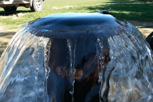
Image source: Aqualink
How is groundwater connected to surface water?
The water cycle connects surface water to groundwater. When water infiltrates and percolates downward through the soil profile, groundwater recharge occurs. Land surface recharge (through deep drainage) is the primary pathway through which water enters an aquifer. Water can also enter an aquifer through natural soil zone bypass when soils are cracked or jointed.
Groundwater can interact with stream in three basic ways:
Gaining stream - a stream can gain groundwater if the elevation of the water table in the vicinity of the stream is higher than the stream water surface. This is typical in areas with a shallow water table. See MAPS – HYDROLOGY for a map showing water table depth.
Losing stream - a stream can lose water to groundwater if the water table is below the elevation of the stream-water surface. In areas where the water table has large variations during the year, a stream segment could receive water from groundwater for a portion of the year and lose water to groundwater at other times.
Losing stream disconnected from groundwater source - where the water table is much lower than the stream, the losing stream will lose water to the unsaturated zone, and the level of the groundwater does not directly affect the flow in the stream.
The movement of water between groundwater and surface water systems leads to the mixing of water with different water qualities. High quantities of nutrients or other dissolved chemicals in surface water can be transferred to the connected groundwater system and vice versa. See S SCIENCE - LANDSCAPE PROCESSES for more information how on water sources and dilution control water quality.
What affects groundwater composition and quality?
As groundwater flows through the aquifer, it dissolves minerals, salts, and other substances from the soils and rocks that it flows through. The composition of the groundwater is largely dependent on the what the aquifer material is. For example, groundwater in a limestone aquifer can contain high concentrations of dissolved calcium carbonate, making the water hard (mineral rich). Similarly, groundwater in a volcanic aquifer contains higher concentrations of dissolved silica dissolved from the volcanic rock, such as the Blue Spring in the Waikato Region. In contrast, groundwater in many of the alluvial gravel aquifers in New Zealand, such as the Canterbury Plains, have low concentrations of dissolved minerals because the aquifer materials are dominated by greywacke gravels that don’t dissolve as rapidly.
Land use also has a significant impact on groundwater quality. Water percolating through the soil can dissolve or leach nutrients (particularly nitrate) and other toxic chemicals (such as pesticides and herbicides) and transport them downward into the underlying aquifer. Animal waste, wastewater discharges and on-site wastewater systems (septic systems) in addition to being a nutrient source, also provide pathogenic micro-organisms (bacteria and viruses) that can also be carried through the soil into the groundwater. Improper waste disposal or leaking pipes and storage tanks can also cause groundwater contamination typically in urban and industrial areas.
When assessing water quality, it important to know what the water is intended to be used for, as some waters will be suitable for crop irrigation, but not for human consumption. For instance, the presence of waterborne microbes can make a drinking water supply unpotable, but it may be satisfactory for the irrigation of an arable crop or vineyard. Municipal or community drinking supplies have the strictest quality requirements that are governed by the Drinking-water Standards for New Zealand 2005 (revised 2018) issued by the Ministry of Health.
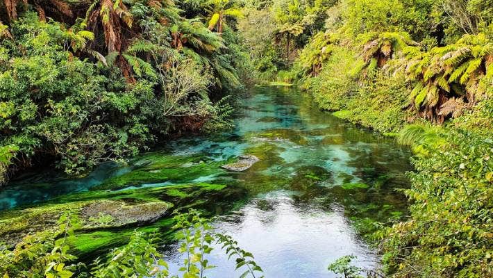
Image source: Stuff
A concept that is important for nitrate contamination, phosphorus solubility, and contamination by heavy metals, is referred to as ”redox”, or reduction–oxidation reactions (see SCIENCE – CHEMICAL PROCESSES for more information).
Under reducing conditions, nitrate can be denitrified and is converted to nitrogen gas. Therefore, nitrate concentrations are very low in groundwater with reducing conditions. On the other hand, some metals are more soluble under reducing conditions, so even though the nitrate concentrations may be low, the groundwater may contain dissolved metals such as iron, manganese, and arsenic. Iron and manganese are key for the sorption of phosphorus to soil and aquifer materials. When they become mobile under reducing conditions, so too does phosphorus.
In many alluvial aquifers in New Zealand, such as the Canterbury Plains, the aquifer sediments contain little or no organic material, and the groundwater remains well oxidised even to great depths below the ground surface. In such areas, nitrate can persist for many decades and travel long distances.
See the redox potential of the geological material in MAPS – CHEMICAL PROCESSES geological reduction potential.