Fencing for Stock exclusion
What
Animals with access to waterways can deposit urine and faeces not only directly in the water but also on surrounding stream banks. Heavy rain and rising water levels can flush this waste into streams. Damage occurs from direct contamination of waterways and the effects on local habitat quality.
Why
New Zealand scientific research published in the international Journal of Environmental Quality led by Dr Richard McDowell has found that smaller streams, less than 1m wide, actually account for the majority (77 %) of the contamination load in a catchment. This research states, “as a result, not requiring smaller streams to be fenced may simply be undermining efforts to stop declining water quality”.
Farmers who fence off streams improve the water quality, as the vegetation filters out nutrients and bacteria from farm runoff. The slowing of overland flow also reduces flood peaks, which in turn reduces erosion of the stream bed. The overall improvement in water quality and cover along the stream margins improves the habitat for fish and bird life and this is enhanced if planting of shrubs is carried out in the riparian area.
Stock activity around and within waterways can:
add sediment and sediment bound-phosphorous from pugging and bank erosion, which reduces water clarity, smothers the stream bed with fine sediment and increases the likelihood of algal blooms
negatively affect other downstream water users
damage aquatic grass beds which are a natural habitat and breeding ground for native fish
spread weeds
Regularly used crossings can be damaging to the habitat downstream of the crossing, though the effects will not be as severe as unlimited access along the banks. Machinery can also cause damage to stream banks, for example, when cultivation or harvesting takes place too close to the stream.
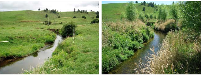
Image source: TeAra
Things to consider prior to fencing for stock exclusion:
Plan what you want to do before fencing.
Fence back far enough to allow for movement of the waterway.
Consider farm layout when putting new waterway fences up.
Plan where crossings will go.
Once fenced, the riparian area will probably need some management. You may require weed or pest animal control.
Regulations
The stock exclusion regulations prohibit the access of cattle, pigs and deer to wetlands, lakes, and rivers. These regulations were developed as part of the Essential Freshwater work programme. The purpose of the regulation is to reduce the impact of damage to our waterways from livestock.
About the regulations:
These regulations came into force on 3 September 2020 and apply to a person who owns or controls beef cattle, dairy cattle, dairy support cattle, deer, or pigs (stock).
The regulations require the person to exclude stock from specified wetlands, lakes, and rivers more than one metre wide.
Dairy cattle, dairy support cattle, and pigs must be excluded from the water bodies regardless of the terrain.
Beef cattle and deer must be excluded from the water bodies regardless of terrain if they are break-feeding or grazing annual forage crops or irrigated pasture. Otherwise, the requirements apply to beef cattle and deer only on mapped low slope land.
Stock must be excluded from the beds of lakes, rivers, and wetlands, and must not be on land closer than three metres to the bed of rivers and lakes. However, stock need not be excluded from land within three metres of the bed if there is a permanent fence in place on 3 September 2020.
Stock, except deer, may only cross a river or lake by using a dedicated bridge or culvert, unless they cross no more than twice in any month. The regulation sets out specified circumstances when cattle and pigs can cross without a dedicated culvert or bridge. Deer are not subject to restrictions for crossing rivers and lakes.
The low slope land maps are part of the regulation and are available to view in the maps section. This data set was created by the Ministry for the Environment with support from Manaaki Whenua - Landcare Research in the selection of elevation model and method for calculating the slope layer.
The mapped areas show low slope land where beef cattle and deer must be excluded from lakes and rivers over one metre wide from 1 July 2025. The mapped areas also show where all cattle, pigs and deer must be excluded from natural wetlands with an area more than 500 square metres from 1 July 2025.
The low slope land map shows land with an average slope less than or equal to 10 degrees across the land parcel, or area of land parcel used for grazing. Land parcels were chosen as the unit of measurement because they provide a readily available boundary with clear ownership or management responsibility. Some steeper land is captured in the areas mapped if the average slope of the whole land parcel is less than 10 degrees.
The low slope map is currently under review by the Ministry for the Environment.
References
Nagels, J. W., Davies-Colley, R. J., Donnison, A. M., & Muirhead, R. W. (2002). Faecal contamination over flood events in a pastoral agricultural stream in New Zealand. Water Science and Technology, 45(12), 45-52.