Manage critical source areas
What
A critical source area is anywhere on a farm that is at risk of losing contaminants. These areas contribute a disproportionately large amount of contaminants to the environment as contaminants are collected and concentrated as water converges and travels through these areas to waterways.
Convergent pathways become critical source areas when the land use or land cover of the contributing area has a source of nutrients, sediment, or microbes. For example, a winter crop paddock has a higher risk of contaminant loss than pasture. In other words, if this area was not used intensively, the water will still converge but the likelihood of contaminants being transferred is much lower. Other common critical source areas include:
Raceways: Raceways are not only good at transporting stock and farm traffic, but also good at transporting contaminants directly into surface water if they are not managed properly. Tracks can transport all four contaminants and often deposit them directly into streams or drains at crossing points. Constructing with good camber and cutoffs alongside can help tracks and races shed water quicker and divert it away from waterbodies.
Stream and River Crossings: Because of their location, poorly designed crossings can discharge a large amount of contaminant into water. Crossings are often situated at the bottom of race or track where contaminants are concentrated. Crossings, like raceways, need to be able to shed water back into paddocks where contaminants can be filtered out.
Cultivated Land and Bare Ground: Periods where soils are bare or without vegetation increases the risk of contaminant loss to waterways. Simple strategies to reduce the risk include not cultivating in areas that have increased slopes, areas that remain wet for extended periods or are likely to become ephemeral waterways. Using low or no-tillage cultivation techniques also helps.
Winter Grazing: Grazing winter crops can cause a large amount of soil loss and damage during winter months. Having heavy animals on wet soils can also decrease productivity. Some management techniques to reduce the risk of contamination include:
- Grazing paddocks strategically so standing crops act as a filter for contaminants.
- Grazing towards rather than away from waterways.
- Leaving a buffer of rank grass around waterways.
- Using a catch crop to pick up surplus nitrogen post-grazing.
Slips, Slumps, and Earth Flows: Erosion is a critical source area because of its ability to lose sediment and phosphorus. Erosion events are common in certain soil types and can be increased by other factors such as stock pressure, weather events or by removing vegetation. Erosion can often be managed by introducing poplar pole planting or reducing grazing pressure on erosion susceptible areas. Providing wide riparian margins or detainment areas can capture contaminants before they enter waterways.
Stock Campsites and In-Paddock Feed Areas: Stock campsites are found in sheltered areas where stock congregate during extreme weather (wet or hot). They can usually be identified by their bare ground and pugging. Some good strategies to manage this include:
- Feed, shade and shelter away from waterways
- Shade and shelter options across the farm
- Placing water troughs appropriately
- Appropriate stock types and rates for the area.
Silage Pits or Feed Bunkers: Silage pits or supplementary feed containers create a critical source area because contaminants could get into waterways. In particular, silage leachate is highly toxic in the water. A well-designed storage area ensures that everything is contained and can be spread through effluent irrigation when conditions are suitable.
Yards and Animal Holding Areas: Yards are critical source areas because they have traditionally been situated near waterways to help with the disposal of waste or chemicals. Animals are usually held here before they are shorn or treated, which can increase contaminant load and risk in these areas. The best way to reduce contaminants from yards is to control the flow of water onto or from these areas. Ensuring liquid has time to be filtered through grass before entering waterways can reduce the level of contaminant entering water.
Intermittent and Ephemeral Waterways: Waterways that flow intermittently are considered risk areas because they can transport contaminants when present. For much of the year, these areas can be grazed like the rest of the paddock. However, during wetter periods they should be excluded from stock grazing and left with a grass buffer, which can help filter out contaminants. It’s also important to not crop through these areas to minimise the impact that cultivation may have.
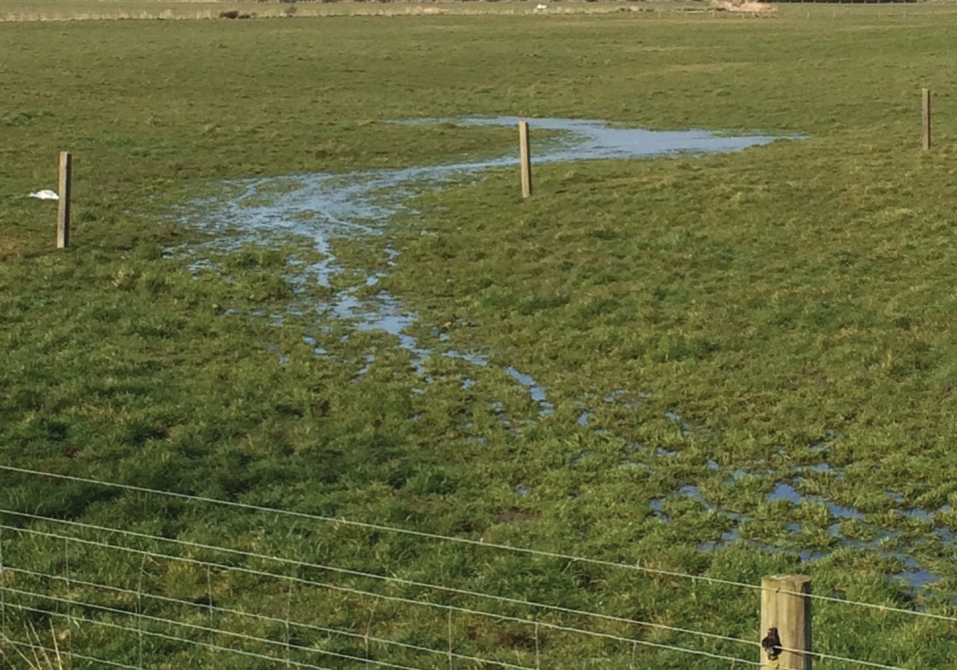
Image source: DairyNZ
Why
Runoff from critical source areas carries sediment, nutrients, and microbes to waterways. Managing these areas well is a good way to reduce nutrient, sediment, and microbial losses from your farm. Within each catchment these small areas of land tend to be the point where disproportionately large amounts of contaminants are lost from, therefore confining mitigation to these areas costs less and can be more effective than targeting wider areas.
In paddock critical source areas can be left as a vegetated buffer which helps to reduce the amount of contaminant being transported to the waterway by physically filtering the particles from the water and reducing and/or slowing the amount of water running off. As a result, its capacity to transport contaminants is significantly lower.
In the figure below, buffer zones of 5, 10 and 30 m around the critical source areas (critical transfer zone) are provided as an example of how mapping can be used to objectively identify these high-risk areas. Buffer widths can be further refined using soil hydrological properties and slope to allow a variable width buffer along the length of the critical transfer pathway.
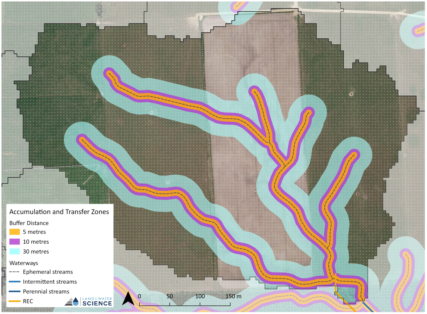
Identification of the critical source areas on farm helps with strategic management of the contributing area. Consideration of things like the placement of water troughs, gateways, and supplement feed, as well as crop grazing planning will help reduce stock movement in these critical source areas. Fencing off critical source areas is also an option, especially for particularly wet areas or in areas with a high land use pressure.
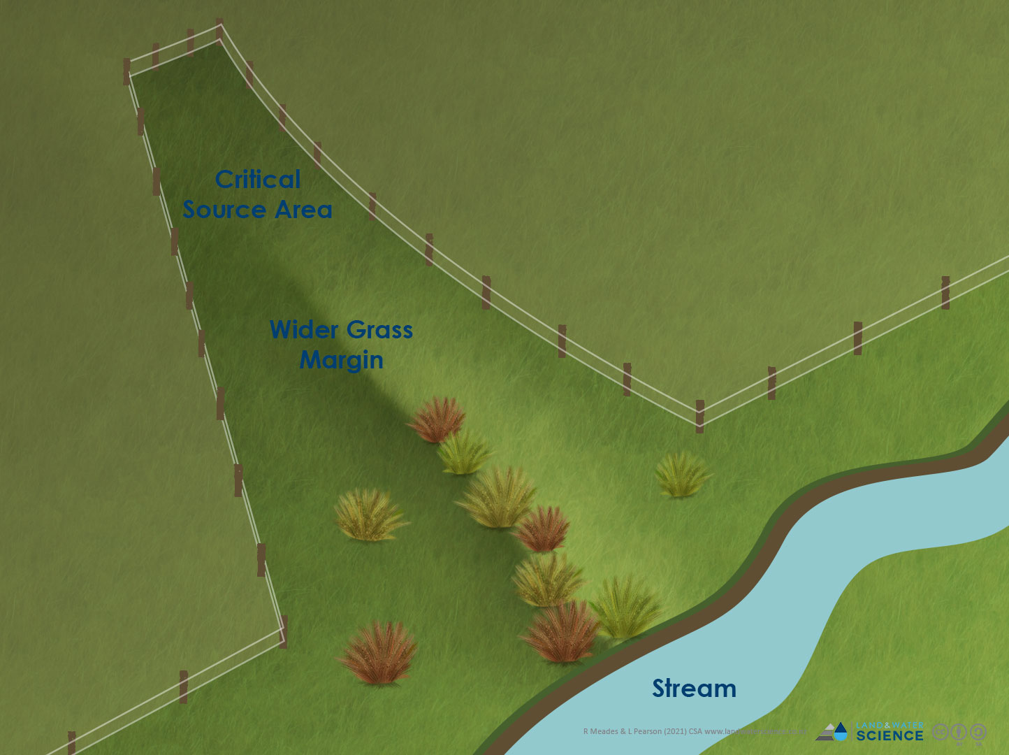
Image Source: Reproduced from DairyNZ
References
Heathwaite, A. L., Quinn, P. F., & Hewett, C. J. M. (2005). Modelling and managing critical source areas of diffuse pollution from agricultural land using flow connectivity simulation. Journal of Hydrology, 304(1-4), 446-461.
Niraula, R., Kalin, L., Srivastava, P., & Anderson, C. J. (2013). Identifying critical source areas of nonpoint source pollution with SWAT and GWLF. Ecological Modelling, 268, 123-133.
Srinivasan, M. S., & McDowell, R. W. (2009). Identifying critical source areas for water quality: 1. Mapping and validating transport areas in three headwater catchments in Otago, New Zealand. Journal of Hydrology, 379(1-2), 54-67.
Strauss, P., Leone, A., Ripa, M. N., Turpin, N., Lescot, J. M., & Laplana, R. (2007). Using critical source areas for targeting cost‐effective best management practices to mitigate phosphorus and sediment transfer at the watershed scale. Soil Use and Management, 23, 144-153.