Oxidising Soil and Aquifer
Occurrence
The Oxidising Soil and Aquifer Environment occurs largely in lowland areas where there are moderately-well to well drained soils and oxygen-rich underlying aquifers. It is commonly associated with volcanic ash or wind and water deposited materials across New Zealand.
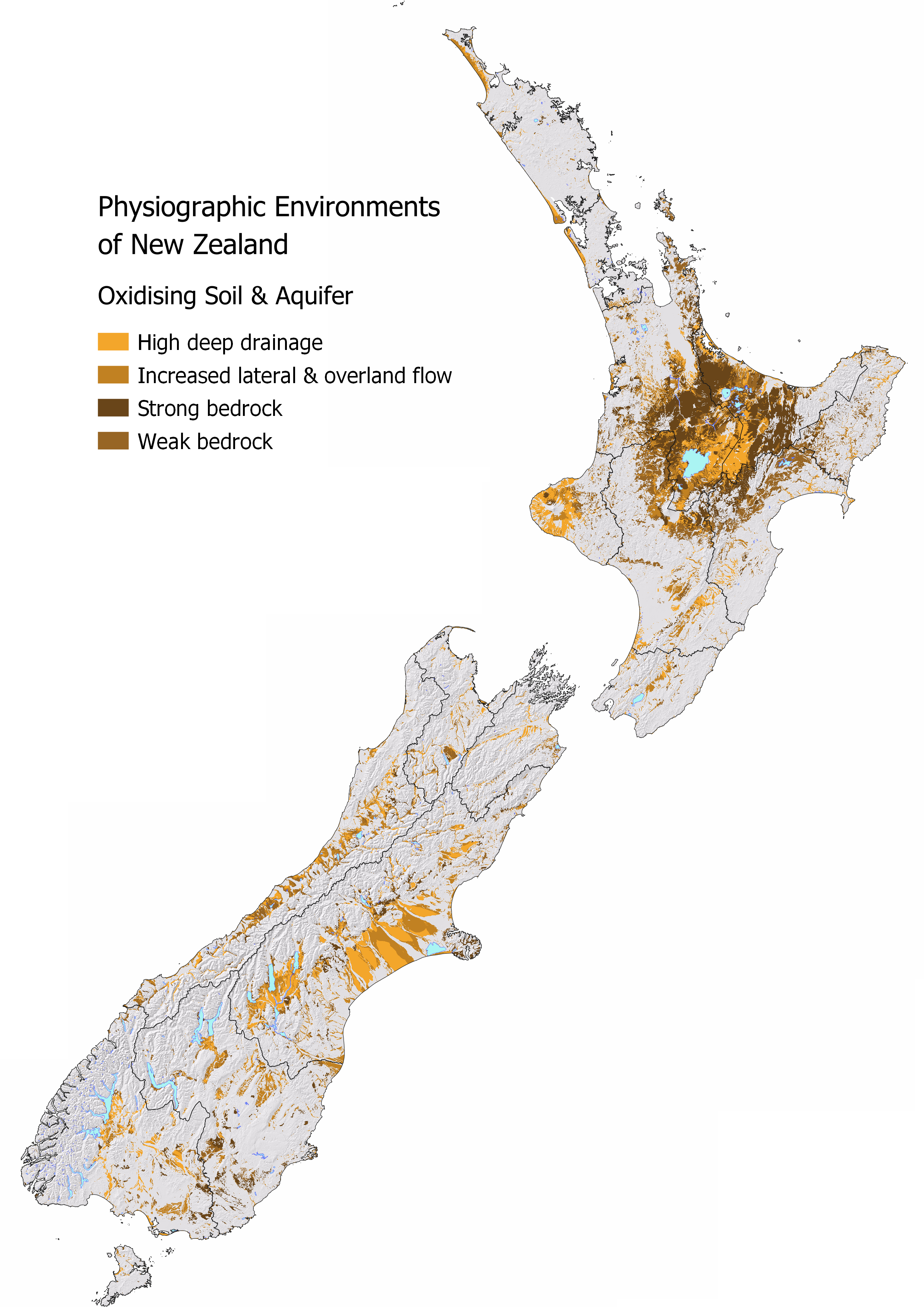
Nationally 21.4% or 5,636,510 ha of New Zealand is classified as Oxidising Soil and Aquifer Environment. Canterbury, Waikato, and Bay of Plenty have the largest areal extent. The Bay of Plenty has the highest proportion of the region classified as Oxidising Soil and Aquifer Environment.
| Region | Total Area (ha) | Percent of Region (%) | Percent of NZ (%) |
|---|---|---|---|
| Canterbury | 1,111,424 | 25.06 | 4.22 |
| Waikato | 1,073,936 | 45.07 | 4.08 |
| Bay of Plenty | 755,516 | 62.82 | 2.87 |
| Manawatu | 548,805 | 24.73 | 2.08 |
| West Coast | 381,119 | 16.47 | 1.45 |
| Hawkes Bay | 377,189 | 26.72 | 1.43 |
| Otago | 349,656 | 11.23 | 1.33 |
| Southland | 301,571 | 9.69 | 1.14 |
| Taranaki | 232,199 | 32.03 | 0.88 |
| Northland | 88,167 | 7.07 | 0.33 |
| Tasman | 87,223 | 9.08 | 0.33 |
| Gisborne | 82,665 | 9.86 | 0.31 |
| Wellington | 70,057 | 8.74 | 0.27 |
| Marlborough | 66,213 | 6.33 | 0.25 |
| Auckland | 46,917 | 9.57 | 0.18 |
| Nelson | 1,492 | 3.55 | 0.01 |
Water Source and Flow Pathway
In this environment, there is a low potential for water dilution from Alpine or Hill Country Environments as local rainfall is the main source of water in this setting. Most rainfall infiltrates the well-drained soils and enters the underlying aquifer by deep drainage.
Landscape Characteristics
The Oxidising Environment has a high ability to filter and adsorb contaminants, reducing the risk of both particulate and dissolved phosphorus, sediment, and microbial losses when water can drain through the soil to depth. However, the risk of nitrate nitrogen leaching is elevated. As the environment has a low ability to remove nitrate naturally, greenhouse gas emissions are also inherently low.
Deep drainage and nitrate leaching are typically seasonal. Leaching to the underlying aquifer occurs when soil moisture is above field capacity or saturated, generally between late autumn and spring. However, deep drainage can occur at any time of the year in response to heavy or sustained rainfall. The deeper the unsaturated zone, the longer it takes for water and nitrate to be transported to the aquifer. This may be days, months to years depending on the water table depth and climate.
Under intensive land uses, nitrate can accumulate to high concentrations in the soil and underlying aquifer over time. This is particularly relevant in areas where there is a deep unsaturated zone or in older more weathered land surfaces.
Variation in the Oxidising Environment occurs where the land is sloping, where soil infiltration rates are low or impeded by slow permeability subsoils increasing the likelihood of runoff occurring. Artificial drainage may also be present in these areas to improve drainage. The environmental risk from all contaminants increases as the soil zone can be bypassed by drainage waters.
In the waterway, high nitrate concentrations can result in excessive algae and plant growth and can be toxic to aquatic organisms. This also reduces the ability to use the waterway for gathering mahinga kai and recreation.
Sibling and Variants
The Oxidising Soil and Aquifer Environment has four siblings:
High deep drainage occurs on flat topography where there are minimal impediments to water draining through the soil profile.
Extent: 1,436,240 ha (5.45% of New Zealand)Increased lateral and overland flow occurs on either undulating topographies or where soils are moderately well-drained resulting in increased lateral or overland flow.
Extent: 1,527,673 ha (5.80% of New Zealand)Over strong bedrock is a transitional class between the Oxidising Soil and Aquifer Environment and the [Strong Bedrock Environment]. This sibling identifies where soils occur over strong bedrock which affects how deep water can drain and limits the aquifer potential of the environment. Strong bedrock is more likely to host fractured rock aquifers than weak bedrock.
Extent: 1,520,765 ha (5.77% of New Zealand)Over weak bedrock is a transitional class between the Oxidising Soil and Aquifer Environment and [Weak Bedrock Environment]. It identifies where soils occur over weak bedrock which affects how deep water can drain and limits the aquifer potential of the environment.
Extent: 1,151,833 ha (4.37% of New Zealand)
Variants are not as common in this environment. In MAPS – PHYSIOGRAPHIC ENVIRONMENTS check to see if any variants apply to your location. Artificial drainage may be present, most likely in the increased lateral and overland flow sibling. In MAPS - HYDROLOGY explore the Overland Flow map to see how runoff risk varies across this environment and the Water Table map for the predicted depth to groundwater. The depth to the water table is especially important in the ‘over bedrock’ siblings as shallow soils will become saturated faster.
| Oxidising Soil & Aquifer Environnent Sibling | Contaminant pathway (dominant hydrological pathway) | How the landscape regulates water quality contaminants | Risk to receiving environment | ||||
|---|---|---|---|---|---|---|---|
| Dilution | Resistance to erosion | Filtration and adsorption | Attenuation: N-Reduction | Attenuation: P-Reduction | |||
| High deep drainage | Deep drainage through the soil zone to an underlying aquifer. Water table depth is an important control over attenuation capacity associated with filtration and retention of contaminants, and the occurrence of overland flow (see Overland Flow variant when pathway is active). | Low | High¹ | High¹ | Low | High | Concentration & load to groundwater |
| Increased lateral and overland flow | Deep drainage through the soil zone to an underlying aquifer with increased lateral and overland flow due to seasonal wetness (see Overland Flow variant when pathway is active). Water table depth is an important control over attenuation capacity associated with filtration and retention of contaminants, and the occurrence of overland flow. | Low | Moderately high - High¹ | Moderately high - High¹ | Low - Moderately low | Moderately high - High | Concentration & load to groundwater, minor surface water |
| Over strong bedrock | Deep drainage until contact with bedrock which transitions to lateral flow. Slope and depth to bedrock controls overland flow risk where the steeper the slope or shallower the bedrock the more likely it is to occur (see Overland Flow variant when pathway is active). | Low | Moderately high – High | Moderate - High | Low - Moderately high² | Moderate² - High | Concentration & load to surface water, minor groundwater contribution |
| Over weak bedrock | Deep drainage until contact with bedrock which transitions to lateral flow. Slope and soil depth controls overland flow risk where the steeper the slope or shallower the soil the more likely runoff is to occur (see Overland Flow variant when pathway is active). | Low | Moderate - High | Moderate - High | Low - Moderately high² | Moderate² - High | Concentration & load to surface water, minor groundwater contribution |
| Hydrological Variants | Occurrence (See MAP VARIANTS to check if they apply at your location) | ||||||
| Artificial drainage | Likely where agricultural soils have impeded drainage or a shallow water table. Pathway is most active during the wetter months. | N/A³ | Moderate – Moderately high | Moderate – Moderately high | Low - Moderate | Moderate – Moderately high | Concentration & load to surface water |
| Overland flow | Occurs when soils are saturated and/or infiltration is limited. Pathway is active after prolonged or intense rainfall. | N/A³ | Low | Low | Low | Low | Concentration & load to surface water |
| Natural soil zone bypass | Occurs when soils are cracked (under soil moisture deficit) or jointed. Pathway is active following extended periods of soil moisture deficit. | N/A³ | Low | Low | Low | Low | Concentration & load to groundwater |
¹ Depth to water table is an important factor. Shallow water table depths are highly connected to the aquifer and contaminants can enter an aquifer relatively quickly. Deep unsaturated zones may take years to reach groundwater.
² Dependent on depth to bedrock and redox state at contact with bedrock.
³ Dilution potential is assessed by the Physiographic Environment recharge domain which is indicative of water source and relative volume. This does not change with the hydrological variant.
Contaminant Profile
| Oxidising Soil & Aquifer Environnent Sibling | Nitrogen | Phosphorus | Sediment | Microbes | |||
|---|---|---|---|---|---|---|---|
| Nitrate & Nitrite | Ammoniacal | Organic (Dissolved & Particulate) | Particulate | Dissolved Reactive | Particulate | Particulate | |
| High deep drainage | High | Low | Low | Low | Low | Low | Low |
| Increased lateral and overland flow | Moderately high - High | Low - Moderately low | Low - Moderately low | Low - Moderately low | Low - Moderately low | Low - Moderately low | Low - Moderately low |
| Over strong bedrock | Moderately low¹ - Moderate | Low - Moderately high¹ | Low - Moderately high¹ | Low - Moderately low | Low - Moderately high¹ | Low - Moderately low | Low - Moderately low |
| Over weak bedrock | Moderately low¹ - Moderate | Low - Moderately high¹ | Low - Moderately high¹ | Low - Moderate | Low - Moderately high¹ | Low - Moderate | Low - Moderate |
| Hydrological variants | |||||||
| Artificial drainage | Moderately low - Moderately high | Moderately low - Moderate | Moderately low - Moderate | Moderate | Moderately low | Moderate | Moderate |
| Overland flow | Low | High | High | High | Low | High | High |
| Natural soil zone bypass | High | High | Moderate | Low | Moderate | Low | High |
¹ Dependent on depth to bedrock and if denitrification occurs at contact with bedrock.
Key Actions
In this environment nitrate reductions should be the primary focus of mitigation activities. Limit the amount of surplus nitrogen in the soil especially prior to the wettest months. Consider deeper rooting crops or pastures to access deeper stores of nitrogen and limit leaching. Maintaining soil structure is also critical to prevent runoff from occurring. In areas that are prone to runoff, vegetated buffer areas, sediment traps, and riparian planting are all ways of intercepting runoff and minimising contaminant losses.