Riverine
Occurrence
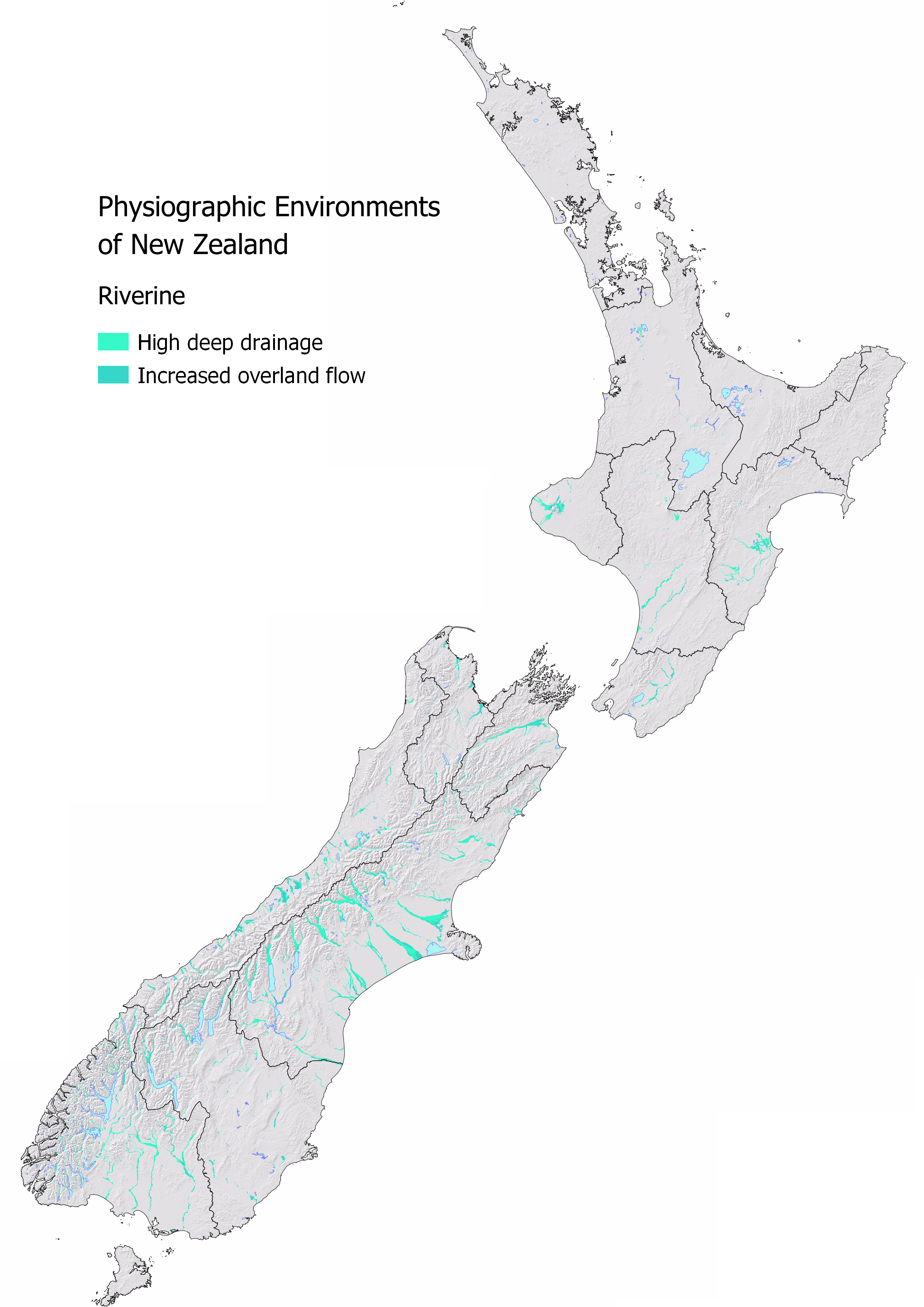
The Riverine Environment occurs along riparian margins next to large main-stem rivers mainly in the South Island of New Zealand. It can extend beyond the riparian margin to include the floodplains and low elevation terraces.
Nationally 2.72% or 717,536 ha of New Zealand is classified as Riverine Environment. Canterbury, Southland, and West Coast have the largest areal extent. Canterbury also has the highest proportion of the region classified as Riverine Environment.
| Region | Area (ha) | Regional (%) | National (%) |
|---|---|---|---|
| Canterbury | 293,600 | 6.62 | 1.11 |
| Southland | 131,403 | 4.22 | 0.50 |
| West Coast | 85,928 | 3.71 | 0.33 |
| Otago | 57,430 | 1.84 | 0.22 |
| Marlborough | 32,692 | 3.13 | 0.12 |
| Hawkes Bay | 31,388 | 2.22 | 0.12 |
| Taranaki | 25,166 | 3.47 | 0.10 |
| Manawatu | 23,645 | 1.07 | 0.09 |
| Tasman | 19,808 | 2.06 | 0.08 |
| Wellington | 11,387 | 1.42 | 0.04 |
| Waikato | 5,090 | 0.21 | 0.02 |
Water Source and Flow Pathway
In the Riverine Environment, Alpine sourced water mixes with Bedrock and lowland water sources from localised rainfall. The main pathway water takes is deep drainage through the soil zone to the underlying aquifer.
Rainfall in this environment drains quickly through the stony soils to the underlying shallow gravel aquifer that is highly connected to the river. Water flows between the aquifer and the river relatively quickly.
Landscape Characteristics
The risk of sediment, particulate phosphorus, and microbial loss is low because the soils are well drained with minimal risk of runoff. However, there is a very high risk of nitrate nitrogen leaching down to the shallow gravel aquifer. This environment is strongly oxidising so there is little to no ability to remove nitrate once it is lost from the root zone. Green-house gas emissions are also inherently low.
Nitrate concentrations are unlikely to build up in the aquifer due to dilution with large volumes of alpine sourced water. However, the total nitrogen load may be high to the receiving rivers, lakes, and estuaries. Although we can’t see nitrogen in the water, we see the effect of an increased nitrogen load as algae and aquatic weeds can dominate the river typically during the summer months when temperatures are warm and river flow is low.
During heavy rainfall events, runoff, artificial drainage, and stream discharges from other parts of the catchment contribute to the increase in nitrogen, phosphorus, sediment, and microbial concentrations in the river.
Overall, river water quality is best closest to alpine areas, where the contaminants in rivers and aquifers are diluted by large volumes of pristine alpine water. Water quality typically declines downstream due to the accumulation of contaminants from all upstream contributing environments.
Sibling and Variations
There are two siblings in the Riverine Environment:
High deep drainage occurs on areas of flat topography where there are minimal impediments to water draining through the soil profile.
Extent: 403,038 ha (1.53% of New Zealand)Increased overland flow occurs on either sloping topographies or where soils are moderately well-drained.
Extent: 314,498 ha (1.19% of New Zealand)
Variants are not as common in this environment. Artificial drainage may be present, most likely in the increased overland flow sibling. In MAPS - HYDROLOGY check the Overland Flow map to see how runoff risk varies across this environment and the Water Table map for the predicted depth to groundwater. The depth to the water table is especially important in this environment as the soil zone is highly connected to the underlying aquifer and river.
| Riverine Environment Sibling | Contaminant pathway (dominant hydrological pathway) | How the landscape regulates water quality contaminants | Risk to receiving environment | ||||
|---|---|---|---|---|---|---|---|
| Dilution | Resistance to erosion | Filtration and adsorption | Attenuation: N-Reduction | Attenuation: P-Reduction | |||
| High deep drainage | Deep drainage through the soil zone to an underlying water table aquifer. Water table depth is an important control over attenuation capacity associated with filtration and retention of contaminants. Water table depth may also govern susceptibility to overland flow (see Overland flow variant when pathway is active). | High | Moderate - High¹ | Moderate - High¹ | Low | Moderate - High¹ | Load to groundwater |
| Increased lateral and overland flow | Deep drainage through the soil zone to an underlying aquifer with increased lateral and overland flow due to slowely permeable soils, seasonal wetness, and sloping land (see Overland flow variant when pathway is active). | High | Moderately high - High¹ | Moderately high - High¹ | Low - Moderately low | Moderately high - High¹ | Load to groundwater, minor surface water |
| Hydrological Variants | Occurrence (See MAP VARIANTS to check if they apply at your location) | ||||||
| Artificial drainage | Likely where agricultural soils have impeded drainage or a shallow water table. Pathway is most active during the wetter months. | N/A² | Moderate – Moderately high | Moderate – Moderately high | Low - Moderate | Moderate – Moderately high | Concentration & load to surface water |
| Overland flow | Occurs when soils are saturated and/or infiltration is limited. Pathway is active after prolonged or intense rainfall. | N/A² | Low | Low | Low | Low | Concentration & load to surface water |
| Natural soil zone bypass | Occurs when soils are cracked (under soil moisture deficit) or jointed. Pathway is active following extended periods of soil moisture deficit | N/A² | Moderate | Low | Low | Low | Concentration & load to groundwater |
¹ Dependent on how active the flood plain is, how well sorted the soil and unsaturated zone materials, and the depth to water table. Where the water table is shallow there is a high connectivity for N loss and risk of overland flow is elevated. P loss can be elevated where soils are dominated by large cobbles with little matrix and the water table is shallow.
² Dilution potential is assessed by the Physiographic Environment recharge domain which is indicative of water source and relative volume. This does not change with the hydrological variant.
Contaminant Profile
| Riverine Environment Sibling | Nitrogen | Phosphorus | Sediment | Microbes | |||
|---|---|---|---|---|---|---|---|
| Nitrate & Nitrite | Ammoniacal | Organic (Dissolved & Particulate) | Particulate | Dissolved Reactive | Particulate | Particulate | |
| High deep drainage | High - N load Low - N conc.¹ | Low | Low | Low | Low | Low | Low |
| Increased lateral and overland flow | High - N load Low - N conc.¹ | Low - Moderately low | Low - Moderately low | Low - Moderately low | Low - Moderately low | Low - Moderately low | Low - Moderately low |
| Hydrological variants | |||||||
| Artificial drainage | Moderately low - Moderately high | Moderately low - Moderate | Moderately low - Moderate | Moderate | Moderately low | Moderate | Moderate |
| Overland flow | Low | High | High | High | Low | High | High |
| Natural soil zone bypass | High | High | Moderate | Low | Moderate | Low | High |
¹ Concentration in groundwater does not increase due to high dilution potential.
Key Actions
In the Riverine Environment, it is important to limit the amount of surplus nitrogen in the soil particularly during the winter months when connectivity with the waterway is high. Protect soil structure to maintain good drainage and minimise the potential for runoff to occur. In areas where runoff does occur, vegetated buffer strips are one way of intercepting contaminants.