Strong Bedrock
Occurrence
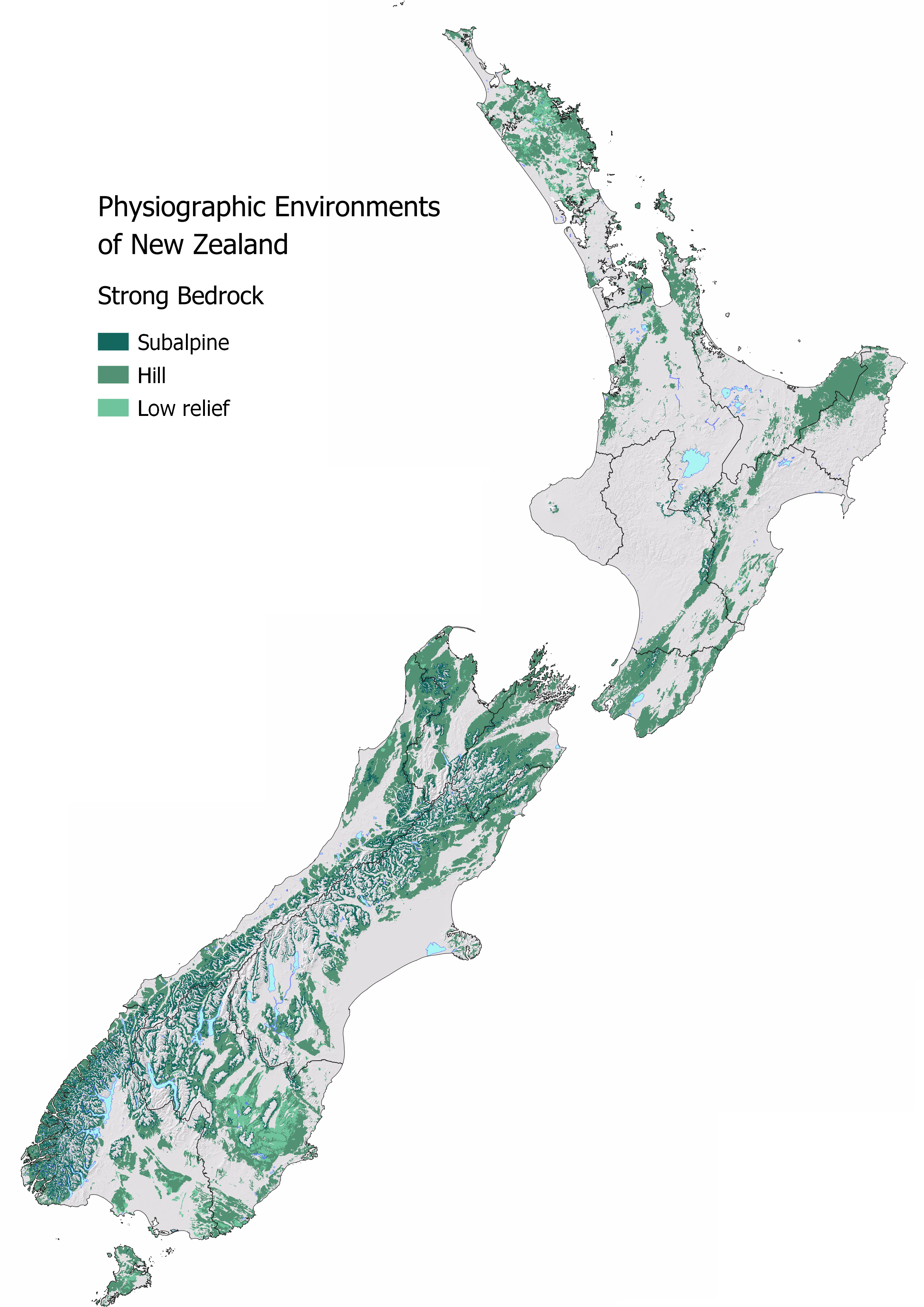
The Strong Bedrock Environment is the most common across New Zealand and is typically identified by rolling to steep topography where shallow soil overlies strong bedrock. This environment has commonly been referred to as ‘Hill Country’, however the Bedrock Environment also exists across plateaus where shallow soils overlie bedrock without any significant relief. Soils in this environment are typically thin and well drained, relative to other lowland environments.
The Strong Bedrock Environment is the largest nationally at 34.34% or 9,045,768 ha of New Zealand. Otago, Canterbury, and Southland have the largest areal extent. Nelson (85.5%) and Marlborough 58.89%) have the highest proportion of their region classified as Strong Bedrock Environment.
| Region | Area (ha) | Regional (%) | National (%) |
|---|---|---|---|
| Otago | 1,459,649 | 46.89 | 5.54 |
| Canterbury | 1,388,839 | 31.32 | 5.27 |
| Southland | 1,302,371 | 41.86 | 4.94 |
| West Coast | 1,118,902 | 48.36 | 4.25 |
| Marlborough | 615,662 | 58.89 | 2.34 |
| Northland | 603,525 | 48.41 | 2.29 |
| Tasman | 511,551 | 53.26 | 1.94 |
| Waikato | 463,370 | 19.45 | 1.76 |
| Wellington | 407,852 | 50.86 | 1.55 |
| Bay of Plenty | 320,854 | 26.68 | 1.22 |
| Hawkes Bay | 260,001 | 18.42 | 0.99 |
| Manawatu | 234,584 | 10.57 | 0.89 |
| Gisborne | 217,567 | 25.96 | 0.83 |
| Auckland | 98,615 | 20.12 | 0.37 |
| Nelson | 35,984 | 85.59 | 0.14 |
| Taranaki | 3,857 | 0.53 | 0.01 |
Water Source and Flow Pathway
The Strong Bedrock Environment typically receives a higher rainfall volume relative to lowland environments. The water source is predominantly local rainfall, except in the subalpine sibling which is hydrologically connected to the Alpine Environment. In the Bedrock Environment, most of the rainfall infiltrates the soil and moves laterally at the contact between the soil and underlying bedrock. If the rock is fractured, then some water will percolate to depth, but is typically relatively minor. Where soils are particularly shallow, rainfall is most likely to runoff as overland flow. As we have cleared native forest or tussock grasslands and developed the land for agriculture and forestry, we have also reduced the ability of the land to store water, resulting in faster more erosive discharges. Volumetrically, a small number of surface runoff events are often responsible for the majority of contaminant transport from land to waterways in this environment.
Waterways are often ephemeral, which means they only occur for short period of time after rainfall. The convergence of small streams across the Bedrock Environment results in more permanent waterways. Significant aquifers are uncommon as recharge to an aquifer is limited by the depth to bedrock and the permeability of the geological material. Fractured rock aquifers are more likely under geologically strong bedrock settings. Seeps and springs are also common in this environment.
Although much of the hydrology is similar between both Bedrock environments, the strength of the underlying bedrock results in different water quality outcomes for some contaminants, particularly sediment.
Landscape Characteristics
Heavy or prolonged rainfall in the Bedrock Environment often results in runoff due to the limited ability of the soil to infiltrate and hold water. Runoff is able to transport loose sediment, sediment-bound nutrients, and microbes quickly to waterways. Due to the stronger nature of the underlying geology, the erosion risk is lower relative to the Weak Bedrock Environment.
Where water infiltrates the soil, it may pool at contact between thin soils and the poorly permeable bedrock. Here, due to redox reactions, the oxygen content of the water decreases, and dissolved iron and manganese may be generated. Under these redox conditions phosphorus tends to be more soluble and mobile and is commonly elevated in hill country streams. Low oxygen conditions also favour the removal of nitrate nitrogen by denitrification. Any denitrification occurring in the soil zone can produce both the harmless dinitrogen gas, which makes up the majority of our atmosphere, and nitrous oxide, a harmful greenhouse gas.
In subalpine environments or where extensive hill country farming occurs, the impact of land use is hard to detect and quantify due to large volumes of dilute alpine or high country sourced water. While water quality is high in these relatively pristine environments, it is still important to reduce contaminant losses as much as possible to minimise the total load delivered to rivers, lakes, and estuaries. As the nutrient status of the soil increases, so too does the risk of the sediment to degrade waterways. Surface water takes and groundwater abstraction from this and neighbouring environments decreases the dilution potential of the water down catchment as the volume of alpine or bedrock sourced water is reduced.
Overall, stream water quality is best the higher up the catchment, where there is less influence by intensive land uses. Water quality typically declines downstream as small streams converge and land use effects accumulate. Seemly small actions that seek to slow down surface runoff and minimise contaminant loss can have a positive effect on downstream water quality.
Sibling and Variations
There are three siblings within the Strong Bedrock Environment:
Subalpine identifies bedrock areas that are hydrologically connected to the Alpine Environment and as a result, have a moderately high dilution potential for downstream receiving environments. This sibling may also have snow accumulation over the winter months. The shallow soils and steeper topography have a greater runoff risk relative to other bedrock areas.
Extent: 2,071,397 ha (7.86% of New Zealand)Hill identifies areas of shallow soils with rolling topography (greater than 8 degrees). This sibling has a moderate dilution potential for downstream receiving environments. Due to the rolling topography, runoff risk is typically higher relative to the low relief sibling.
Extent: 6,331,097 ha (24.04% of New Zealand)Low relief maps bedrock areas less than 8 degrees. This sibling has a moderate to low dilution potential for downstream receiving environments. Runoff risk is typically lower than the other bedrock environments.
Extent: 643,274 ha (2.44% of New Zealand)
Variants are uncommon in this environment. In MAPS - HYDROLOGY check the Overland Flow map to see how runoff risk varies across this environment. In MAPS – PHYSIOGRAPHIC ENVIRONMENTS check to see if any other variants apply to your location.
| Strong Bedrock Environment Sibling | Contaminant pathway (dominant hydrological pathway) | How the landscape regulates water quality contaminants | Risk to receiving environment | ||||
|---|---|---|---|---|---|---|---|
| Dilution | Resistance to erosion | Filtration and adsorption | Attenuation: N-Reduction | Attenuation: P-Reduction | |||
| Subalpine | Lateral drainage through the soil zone either to stream or a neighbouring lowland environment. Recharge to the underlying aquifer is limited by the permeability of the bedrock. Overland flow is common due to seasonal wetness (see Overland flow variant when pathway is active). | Moderately high | Low - Moderately low | Moderately low | Moderate | Moderate - Low | Load to surface water |
| Hill | Lateral drainage along contact with bedrock discharging to stream or neighbouring environment. Slope and depth to bedrock controls overland flow risk where the steeper the slope or shallower the bedrock the more likely it is to occur (see Overland flow variant when pathway is active). Limited aquifer potential unless bedrock is fractured. | Moderate | Moderately low - Moderate | Moderately low - Moderate | Moderately high | Moderately low | Concentration & load to surface water, minor groundwater contribution |
| Low relief | Lateral drainage along contact with bedrock discharging to stream or neighbouring environment. Depth to bedrock controls overland flow risk where the shallower the bedrock the more likely it is to occur (see Overland flow variant when pathway is active). Limited aquifer potential unless bedrock is fractured. | Moderate - Low | Moderately low -Moderate | Moderately low - Moderate | Moderately high | Moderately low | Concentration & load to surface water, minor groundwater contribution |
| Hydrological Variants | Occurrence (See MAP VARIANTS to check if they apply at your location) | ||||||
| Overland flow | Occurs when soils are saturated and/or infiltration is limited. Pathway is active after prolonged or intense rainfall. | N/A¹ | Low | Low | Low | Low | Concentration & load to surface water |
| Natural soil zone bypass | Occurs when soils are cracked (under soil moisture deficit) or jointed. Pathway is active following extended periods of soil moisture deficit. | N/A¹ | Moderate | Low | Low | Low | Concentration & load to groundwater |
¹ Dilution potential is assessed by the Physiographic Environment recharge domain which is indicative of water source and relative volume. This does not change with hydrological variant.
Contaminant Profile
| Strong Bedrock Environment | Nitrogen | Phosphorus | Sediment | Microbes | |||
|---|---|---|---|---|---|---|---|
| Nitrate & Nitrite | Ammoniacal | Organic (Dissolved & Particulate) | Particulate | Dissolved Reactive | Particulate | Particulate | |
| Subalpine | Moderately high | Moderately high | Moderately high | Moderately high | Moderately high | Moderately high | Moderately high |
| Hill | Low - Moderate | Moderate - Moderately high | Moderate - Moderately high | Moderate - Moderately high | Moderate - Moderately high | Moderate - Moderately high | Moderate - Moderately high |
| Low relief | Low - Moderate | Moderate - Moderately high | Moderate - Moderately high | Moderate - Moderately high | Moderate - Moderately high | Moderate - Moderately high | Moderate - Moderately high |
| Hydrological variants | |||||||
| Overland flow | Low | High | High | High | Low | High | High |
| Natural soil zone bypass | High | High | Moderate | Low | Moderate | Low | High |
Key Actions
In the Bedrock environments, maintain vegetation cover as soils are especially vulnerable to loss on sloping land. Shallow soils are especially vulnerable to phosphorus loss, therefore low solubility fertilisers are advised. Incorporate native vegetation where possible, such as tussocks and grasses, to help increase the carbon content of the soil and the ability of the soil to store water. Native species, such as Pittosporum, are also effective for stabilising land and minimising gully erosion. Small retention dams can also be built to trap sediment.