Oxidising Soil Reducing Aquifer
Occurrence
The Oxidising Soil Reducing Aquifer Environment occurs predominantly in lowland areas where there are moderately well to well drained soils and oxygen limited underlying aquifers. Aquifers can be moderate to highly reducing depending on the carbon content of the underlying geology. Typical reducing geologies include mudstones, marine or estuarine sediments, lignite and coal measure sediments, and peats. Moderately reducing aquifers can also occur in areas where oxygen becomes limited by shallow poorly permeable bedrock regardless of the composition of the underlying geology.
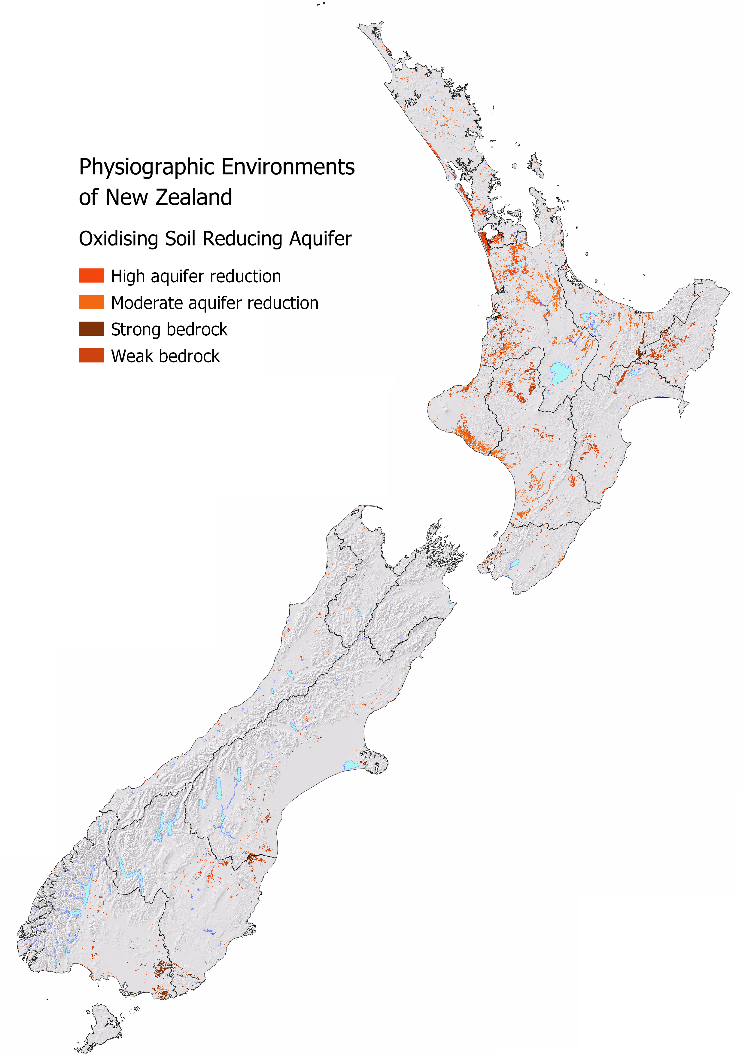
Nationally 3.43% or 902,592 ha of New Zealand is classified as Oxidising Soil Reducing Aquifer Environment. Waikato, Manawatu, and Taranaki have the largest areal extent. Auckland has the highest proportion of the region classified as Oxidising Soil Reducing Aquifer Environment.
| Region | Area (ha) | Regional (%) | National (%) |
|---|---|---|---|
| Waikato | 254,176 | 10.67 | 0.97 |
| Manawatu | 137,286 | 6.19 | 0.52 |
| Taranaki | 80,059 | 11.04 | 0.30 |
| Bay of Plenty | 61,360 | 5.10 | 0.23 |
| Southland | 59,011 | 1.90 | 0.22 |
| Auckland | 58,932 | 12.02 | 0.22 |
| Otago | 55,396 | 1.78 | 0.21 |
| Hawkes Bay | 40,352 | 2.86 | 0.15 |
| Northland | 35,171 | 2.82 | 0.13 |
| Canterbury | 34,770 | 0.78 | 0.13 |
| Gisborne | 23,089 | 2.75 | 0.09 |
| Wellington | 20,208 | 2.52 | 0.08 |
| West Coast | 10,010 | 0.43 | 0.04 |
| Tasman | 2,310 | 0.24 | 0.01 |
| Marlborough | 135 | 0.01 | 0.00 |
| Nelson | 3 | 0.01 | 0.00 |
Water Source and Flow Pathway
In this environment there is a low potential for water dilution from Alpine or Hill Country Environments as local rainfall is the main source of water in this setting. Local rainfall infiltrates through the well-drained soils by deep drainage to the underlying aquifer where microbial activity modifies the oxic soil water resulting in a reducing aquifer.
Landscape Characteristics
The Oxidising Soil Reducing Aquifer environment has a high ability to filter and adsorb contaminants in the soil zone, reducing the risk of both dissolved and particulate phosphorus, sediment, and microbial losses when water can drain through the soil to depth. In soils with a low phosphorus retention, such as sandy or strongly weathered soils, leached dissolved reactive phosphorus is at higher risk of loss as it is more soluble under reducing conditions.
Leached nitrate nitrogen from the soil zone is reduced by denitrification in the underlying aquifer. Denitrification is a natural process involving microorganisms that converts dissolved nitrate to dinitrogen gas, the harmless gas that makes up 78% of the Earth’s atmosphere. This process can also produce nitrous oxide, a harmful greenhouse gas, if the denitrification process is incomplete. Under intensive land uses, the reduction capacity of the aquifer can become overwhelmed if nitrate loss exceeds the rate at which the environment can remove it.
Sibling and Variations
The Oxidising Soil Reducing Aquifer Environment has four siblings:
High aquifer reduction occurs over areas with either peat, marine terraces, or lignite in the underlying geology.
Extent: 897,764 ha (3.41% of New Zealand)Moderate aquifer reduction typically has mudstones as the underlying geology.
Extent: 897,764 ha (3.41% of New Zealand)Over strong bedrock is a transitional class between the Oxidising Soil Reducing Aquifer Environment and the [Strong Bedrock Environment]. This sibling identifies where soils occur over strong bedrock which affects how deep water can drain and limits the aquifer potential of the environment. Strong bedrock is more likely to host fractured rock aquifers than weak bedrock.
Extent: 897,764 ha (3.41% of New Zealand)Over weak bedrock is a transitional class between the Oxidising Soil Reducing Aquifer Environment and [Weak Bedrock Environment]. It identifies where soils occur over weak bedrock which affects how deep water can drain and limits the aquifer potential of the environment.
Extent: 897,764 ha (3.41% of New Zealand)
Variants are not as common in this environment. Artificial drainage may be present, most likely in the increased lateral and overland flow sibling. In MAPS - HYDROLOGY check the Overland Flow map to see how runoff risk varies across this environment and the Water Table map for the predicted depth to groundwater. The depth to the water table is especially important in this Environment as shallow soils will become saturated faster. In areas where the water table is shallow or where there is poorly permeable aquifer material groundwater upwelling can occur that drains laterally and often forms a seep or wetland areas. Artificial drainage may have been put in place in these areas to intercept the groundwater.
| Oxidising Soil Reducing Aquifer Environment Sibling | Contaminant pathway (dominant hydrological pathway) | How the landscape regulates water quality contaminants | Risk to receiving environment | ||||
|---|---|---|---|---|---|---|---|
| Dilution | Resistance to erosion | Filtration and adsorption | Attenuation: N-Reduction | Attenuation: P-Reduction | |||
| High aquifer reduction | Deep drainage through the soil zone to an underlying water table aquifer. Water table depth is an important control over attenuation capacity associated with filtration and retention of contaminants. | Low | Moderately high – High | Moderately high - High | High¹ | High¹ (soil zone retention) | Minimal if water drains to groundwater |
| Moderate aquifer reduction | Deep drainage through the soil zone to an underlying aquifer with increased lateral and overland flow due to seasonal wetness (see Overland flow variant when pathway is active). Water table depth is an important control over attenuation capacity associated with filtration and retention of contaminants. | Low | Moderately high - High | Moderately high - High | Moderately high - High | Moderately high - High | Minimal if water drains to groundwater |
| Over strong bedrock | Deep drainage until contact with bedrock which transitions to lateral flow. Slope and depth to bedrock controls overland flow risk where the steeper the slope or shallower the bedrock the more likely it is to occur (see Overland flow variant when pathway is active). | Low | Moderately high – High | Moderately high - High | Moderate - High | Moderate - High | Minimal if water drains through soil to surface water |
| Over weak bedrock | Deep drainage until contact with bedrock which transitions to lateral flow. Slope and soil depth controls overland flow risk where the steeper the slope or shallower the soil the more likely runoff is to occur (see Overland flow variant when pathway is active). | Low | Moderate - High | Moderate - High | Moderate - High | Moderate - High | Minimal if water drains through soil to surface water |
| Hydrological Variants | Occurrence (See MAP VARIANTS to check if they apply at your location) | ||||||
| Artificial drainage | Likely where agricultural soils have impeded drainage or a shallow water table. Pathway is most active during the wetter months. | N/A² | Moderate – Moderately high | Moderate – Moderately high | Low - Moderate | Moderate – Moderately high | Concentration & load to surface water |
| Overland flow | Occurs when soils are saturated and/or infiltration is limited. Pathway is active after prolonged or intense rainfall. | N/A² | Low | Low | Low | Low | Concentration & load to surface water |
| Natural soil zone bypass | Occurs when soils are cracked (under soil moisture deficit) or jointed. Pathway is active when soils are very dry with the highest risk occurring after prolonged dry periods. | N/A² | Moderate | Low | Low | Low | Concentration & load to groundwater |
¹ The stronger the reducing conditions the more likely nitrogen reduction via denitrification will occur, however phosphorus becomes more mobile (reduction is low). In oxidising conditions, phosphorus reduction is high and nitrogen reduction is low.
² Dilution potential is assessed by the Physiographic Environment recharge domain which is indicative of water source and relative volume. This does not change with the hydrological variant.
Contaminant Profile
| Oxidising Soil Reducing Aquifer Environment Sibling | Nitrogen | Phosphorus | Sediment | Microbes | |||
|---|---|---|---|---|---|---|---|
| Nitrate & Nitrite | Ammoniacal | Organic (Dissolved & Particulate) | Particulate | Dissolved Reactive | Particulate | Particulate | |
| High aquifer reduction | Low - Moderately low | Low - Moderately low | Low - Moderately low | Low | Low | Low - Moderately low | Low |
| Moderate aquifer reduction | Low - Moderately low | Low - Moderately low | Low - Moderately low | Low - Moderately low | Low - Moderately low | Low - Moderately low | Low - Moderately low |
| Over strong bedrock | Low - Moderately low | Low - Moderate | Low - Moderate | Low - Moderately low | Low – Moderately Low | Low - Moderate | Low - Moderate |
| Over weak bedrock | Low - Moderately low | Low - Moderate | Low - Moderate | Low - Moderate | Low – Moderately Low | Low - Moderate | Low - Moderate |
| Hydrological variants | |||||||
| Artificial drainage | Moderately low - Moderately high | Moderately low - Moderate | Moderately low - Moderate | Moderate | Moderately low | Moderate | Moderate |
| Overland flow | Low | High | High | High | Low | High | High |
| Natural soil zone bypass | High | High | Moderate | Low | Moderate | Low | High |
Key Actions
In this environment, mitigation activities should focus on preventing bypass pathways. Maintaining good soil structure is critical to prevent runoff from occurring. In areas that are prone to runoff, vegetated buffer areas, sediment traps, and riparian planting are all ways of intercepting runoff and minimising contaminant loss. In soils with a low P-retention, limit the amount of surplus phosphorus by using low solubility fertilisers.