Wetlands
Occurrence
The Wetlands Environment occurs across New Zealand where there are organic-rich peat soils and aquifers. It is associated with both current and former wetlands. Wetlands form in low points or depressions in the landscape where organic matter has accumulated to form peat over hundreds of years. Wetlands are naturally acidic, a sink for carbon, and low in oxygen, resulting in a highly reducing environment.
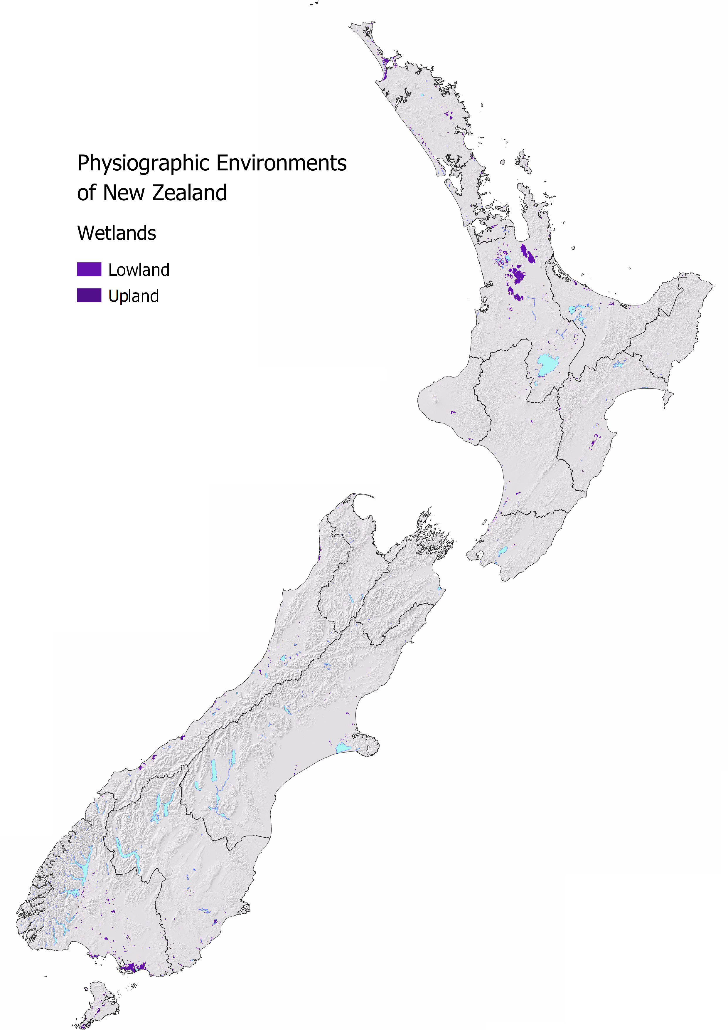
Nationally 0.82% or 216,815 ha of New Zealand is classified as Wetland Environment. Waikato, Southland, and Northland have the largest areal extent. Waikato also has the highest proportion of the region at 3.84% classified as Wetlands Environment.
| Region | Area (ha) | Regional (%) | National (%) |
|---|---|---|---|
| Waikato | 91,571 | 3.84 | 0.35 |
| Southland | 48,939 | 1.57 | 0.19 |
| Northland | 25,073 | 2.01 | 0.10 |
| West Coast | 14,450 | 0.62 | 0.05 |
| Hawkes Bay | 7,520 | 0.53 | 0.03 |
| Otago | 7,323 | 0.24 | 0.03 |
| Bay of Plenty | 6,034 | 0.50 | 0.02 |
| Auckland | 4,116 | 0.84 | 0.02 |
| Canterbury | 3,645 | 0.08 | 0.01 |
| Manawatu | 3,175 | 0.14 | 0.01 |
| Gisborne | 2,404 | 0.29 | 0.01 |
| Taranaki | 2,123 | 0.29 | 0.01 |
| Wellington | 1,785 | 0.22 | 0.01 |
| Tasman | 808 | 0.08 | 0.00 |
| Marlborough | 11 | 0.00 | 0.00 |
Water Source and Flow Pathway
In this environment the water table is near the land surface and soil drainage is very poor. The main pathways drainage typically takes from a wetland is shallow lateral flow and overland flow.
Drainage waters have naturally higher organic nitrogen and dissolved reactive phosphorus concentrations from the breakdown of the peat. Tannins from the organic matter give the drainage water a tea colour.
Agricultural production has modified both the chemistry and hydrology of the Wetland Environment significantly. Lime is added to reduce the acidity of the soil and make it suitable for agriculture. Drainage ditches and subsurface drains are used to lower the water table, allowing oxygen into the soils. This causes the peat to breakdown at a much faster rate and shrink over time.
Landscape Characteristics
In this environment, denitrification rapidly converts nitrate nitrogen into gaseous forms, including the greenhouse gas, nitrous oxide. Nitrogen can also be lost through the drainage network in this environment largely in the form of ammoniacal nitrogen from the breakdown of animal waste and organic nitrogen from the breakdown of organic matter. This nitrogen is often converted to nitrate in the receiving streams, lakes, and estuaries.
As the soils are organic, there is limited mineral material to hold added phosphates in the soil. The strongly reducing conditions makes both particulate and dissolved forms of phosphorus highly mobile. Ponding on the land surface or runoff can occur frequently due to the shallow water table, increasing the likelihood that all contaminants are transported to the waterway.
The incorporation of wetlands back into an agricultural landscape can have many benefits. They are best located in areas where water naturally accumulates and drains. Wetlands act like the ‘kidneys of the landscape’ because they filter, absorb, and remove contaminants from water, particularly from runoff and shallow groundwater. During times of rainfall, they act like a sponge to store and slowly release water which helps to reduce issues, such as localised flooding. Due to their limited extent, much effort is going into the protection and restoration of these natural systems.
Sibling and Variations
There are two siblings in the Wetland Environment:
Lowland wetlands are more likely to have deeper peat development and greater extent relative to wetlands located in the upland areas. Peat bogs are the most common wetland type in this sibling.
Extent: 191,542 ha (0.73% of New Zealand)Upland wetlands are often located in small basins, gullies, and areas where water converges. They are often smaller and shallower in extent than lowland wetlands. Many of the wetlands located in alpine and subalpine environments are smaller than the scale of the mapping.
Extent: 25,273 ha (0.1% of New Zealand)
Variants have a large role in changing the predicted hydrological response and contaminant risk profile in this environment and are highly seasonal. Check if they apply for your location MAPS.
- Artificial drainage variant is common in areas of agricultural land and changes the predicted contaminant profile. See Artificial Drainage Variant for more details.
- Overland flow risk is elevated in areas of agricultural land and changes the predicted contaminant profile, especially over the wetter months when the water table is high and soils can become saturated easily. See Overland Flow Variant for more details.
| Wetlands Environment Sibling | Contaminant pathway (dominant hydrological pathway) | How the landscape regulates water quality contaminants | Risk to receiving environment | ||||
|---|---|---|---|---|---|---|---|
| Dilution | Resistance to erosion | Filtration and adsorption | Attenuation: N-Reduction | Attenuation: P-Reduction | |||
| Lowland | Lateral drainage through the soil zone either to stream or a neighbouring environment. Overland flow occurs more often than other lowland environments due to the shallow water table (see Overland flow variant when pathway is active). Artificial drainage is common under agricultural land uses (see Artificial Drainage variant details if present). | Low | Low - Moderate | Moderately high – High filtration (low anion exchange) | High | Low | Concentration & load to surface water, minor groundwater contribution |
| Upland | Lateral drainage through the soil zone either to stream or a neighbouring environment. Overland flow occurs due to the limited storage capacity in the soil zone in upland environments and seasonal wetness (see Overland flow variant when pathway is active). Artificial drainage is likely under agricultural land uses (see Artificial Drainage variant details if present). | Low - High | Low – Moderately low | Moderate – High filtration (low anion exchange) | High | Low | Concentration & load to surface water, minor groundwater contribution |
| Hydrological Variants | Occurrence (See MAP VARIANTS to check if they apply at your location) | ||||||
| Artificial drainage | Likely where agricultural soils have impeded drainage or a shallow water table. Pathway is most active during the wetter months. | N/A¹ | Moderate – Moderately high | Moderate – Moderately high | Low - Moderate | Moderate – Moderately high | Concentration & load to surface water |
| Overland flow | Occurs when soils are saturated and/or infiltration is limited. Pathway is active after prolonged or intense rainfall. | N/A¹ | Low | Low | Low | Low | Concentration & load to surface water |
¹ Dilution potential is assessed by the Physiographic Environment recharge domain which is indicative of water source and relative volume. This does not change with the hydrological variant.
Contaminant Profile
| Wetlands Environment | Nitrogen | Phosphorus | Sediment | Microbes | |||
|---|---|---|---|---|---|---|---|
| Nitrate & Nitrite | Ammoniacal | Organic (Dissolved & Particulate) | Particulate | Dissolved Reactive | Particulate | Particulate | |
| Lowland | Low | High | High | High | Moderately high | Moderate¹ – Moderately high | High |
| Upland | Low | High | High | Moderately high - High | Moderate - Moderately high | Moderate¹ – Moderately high | High |
| Hydrological variants | |||||||
| Artificial drainage | Moderately low - Moderately high | Moderately low - Moderate | Moderately low - Moderate | Moderate | Moderately low | Moderate | Moderate |
| Overland flow | Low | High | High | High | Low | High | High |
¹ Sediment is largely organic material.
Key Actions
In the Wetlands Environment, reduce intensive grazing of livestock, particularly during wetter months to reduce losses of all contaminants. Apply less soluble forms of phosphate fertilisers in lower application rates as it is highly mobile in the Wetland environment. Restore former wetland environments to enhance the natural capacity of the land and reduce agricultural contaminants in drainage waters from nearby areas.